


Graphical Abstract
- Volume 98, Issue 1 (February)
- Volume 98, Issue 2 (April)
- Volume 98, Issue 3 (June)
- Volume 98, Issue 4 (August)
- Volume 98, Issue 5 (October)
- Volume 98, Issue 6 (December)
JMSJ, 2020, Vol. 98, No. 1 (February)
Review Articles
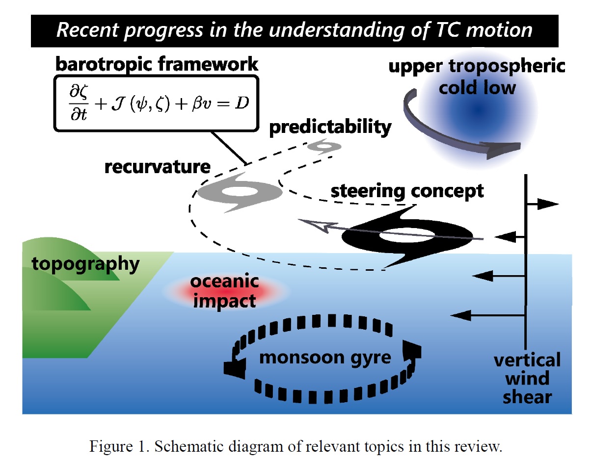
Ito et al. (2020)
Ito, K., C.-C. Wu, K. T. F. Chan, R. Toumi, and C. Davis, 2020: Recent progress in the fundamental understanding of tropical cyclone motion. J. Meteor. Soc. Japan, 98, 5-17.
https://doi.org/10.2151/jmsj.2020-001
Graphical Abstract
Plain Language Summary: Because of its importance of the tropical cyclone (TC) track, extensive studies have been carried out. While the understanding of the motion of TCs is fairly mature, notable advancements are still being made very recently. This paper summarizes new concepts and updates to the existing theories, particularly since 2014, as follows: revisiting the concept of steering flow, barotropic framework, recurvature, influence of topography, role of atmosphere-ocean interaction, large scale features, and dynamics of large forecast errors in TC tracks.
Highlights:
- New concepts and updates to the existing fundamental theories on TC movement obtained from simplified barotropic models, full-physics models, and data analysis are reviewed.
- The content includes the following topics: steering flow, barotropic models, vortex Rossby waves, singular vector analysis, horizontal wind shear, recurvature, potential vorticity tendency equation, terrain-induced gyre, channeling effect, oceanic impact, monsoon gyre, upper tropospheric cold low, subtropical high, saddle point, vertical wind shear, and cumulus convection scheme.
- Although the conventional concepts remain important, the deeper understanding of existing theories and the consideration of the physical processes that were previously thought of as "minor" have become important with the errors in track forecasts decreasing over several decades.
Review Articles
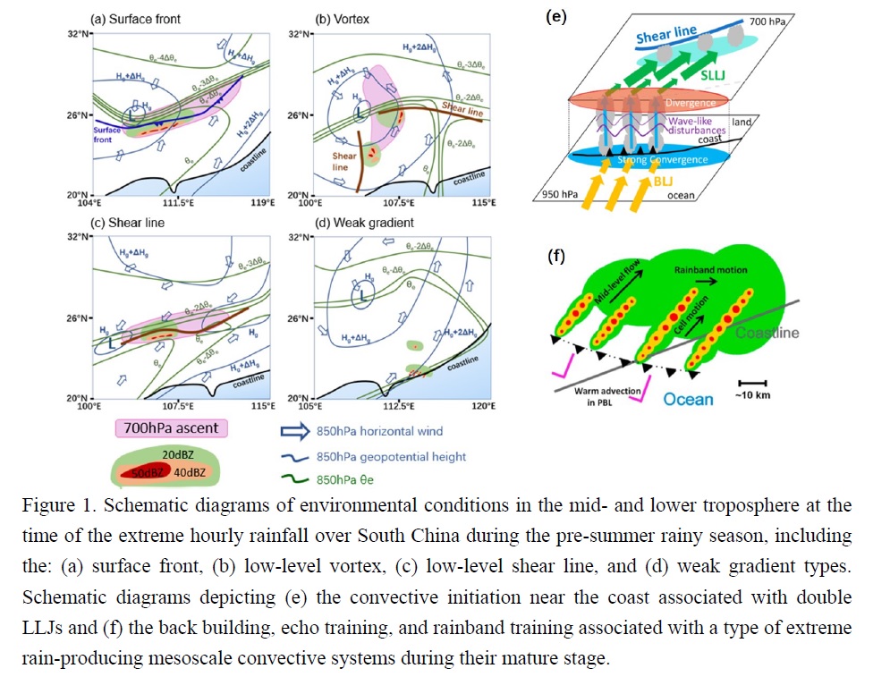
Luo et al. (2020)
Luo, Y., R. Xia, and J. C. L. Chan, 2020: Characteristics, physical mechanisms, and prediction of pre-summer rainfall over South China: research progress during 2008-2019. J. Meteor. Soc. Japan, 98, 19-42.
https://doi.org/10.2151/jmsj.2020-002
Graphical Abstract
Plain Language Summary: Pre-summer rainy season (April to mid-June) over South China is characterized by high intensity and frequent occurrence of heavy rainfall in the East Asian monsoon region. This review describes recent progress in the research related to such a phenomenon, including the temporal and spatial characteristics of the rainfall, new insights into the relevant multiscale processes governing initiation and development of rainstorms, and convection-permitting modeling studies aiming at improving the quantitative precipitation forecast skill.
Highlights:
- Average rainfall distribution, diurnal variation of rainfall, and climatology of extreme hourly precipitation are described including a comparison before and after the monsoon onset over South China Sea.
- Association between the heavy rainfall and multi-scale factors, such as SSTs over tropical oceans, synoptic disturbances, mesoscale processes, and microphysical features, are discussed.
- NWP studies summarized include data-assimilation impact studies, evaluation and improvement of cloud microphysics parameterizations, and development of ensemble forecast technique.
Articles
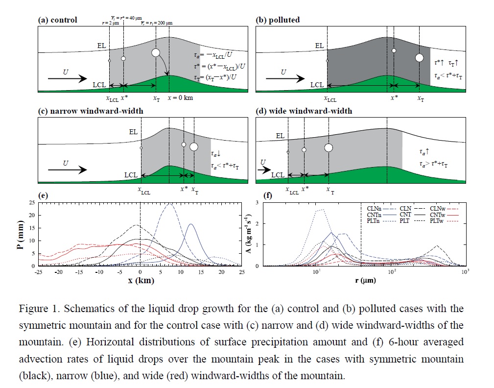
Seo et al. (2020)
Seo, J. M., H. Lee, S. Moon, and J.-J. Baik, 2020: How mountain geometry affects aerosol-cloud-precipitation interactions: Part I. Shallow convective clouds. J. Meteor. Soc. Japan, 98, 43-60.
https://doi.org/10.2151/jmsj.2020-003
Graphical Abstract
Plain Language Summary: We examine how mountain upslope geometry controls aerosol effects on orographic precipitation from shallow warm convective clouds through idealized simulations using the WRF model with a bin microphysics scheme. The windward-width of the mountain controls advection timescale of liquid drops. Greater aerosol loading leads to reduction and downstream shift of precipitation. The aerosol effects are more clearly seen when the windward-width of the mountain is narrower.
Highlights:
- We study how mountain upslope and aerosol loading affect orographic precipitation.
- Warm convective clouds are simulated using WRF model with a bin microphysics scheme.
- Greater aerosol loading leads to reduction and downstream shift of precipitation.
- The narrower windward-width of the mountain, the clearer the aerosol effects are.
Articles
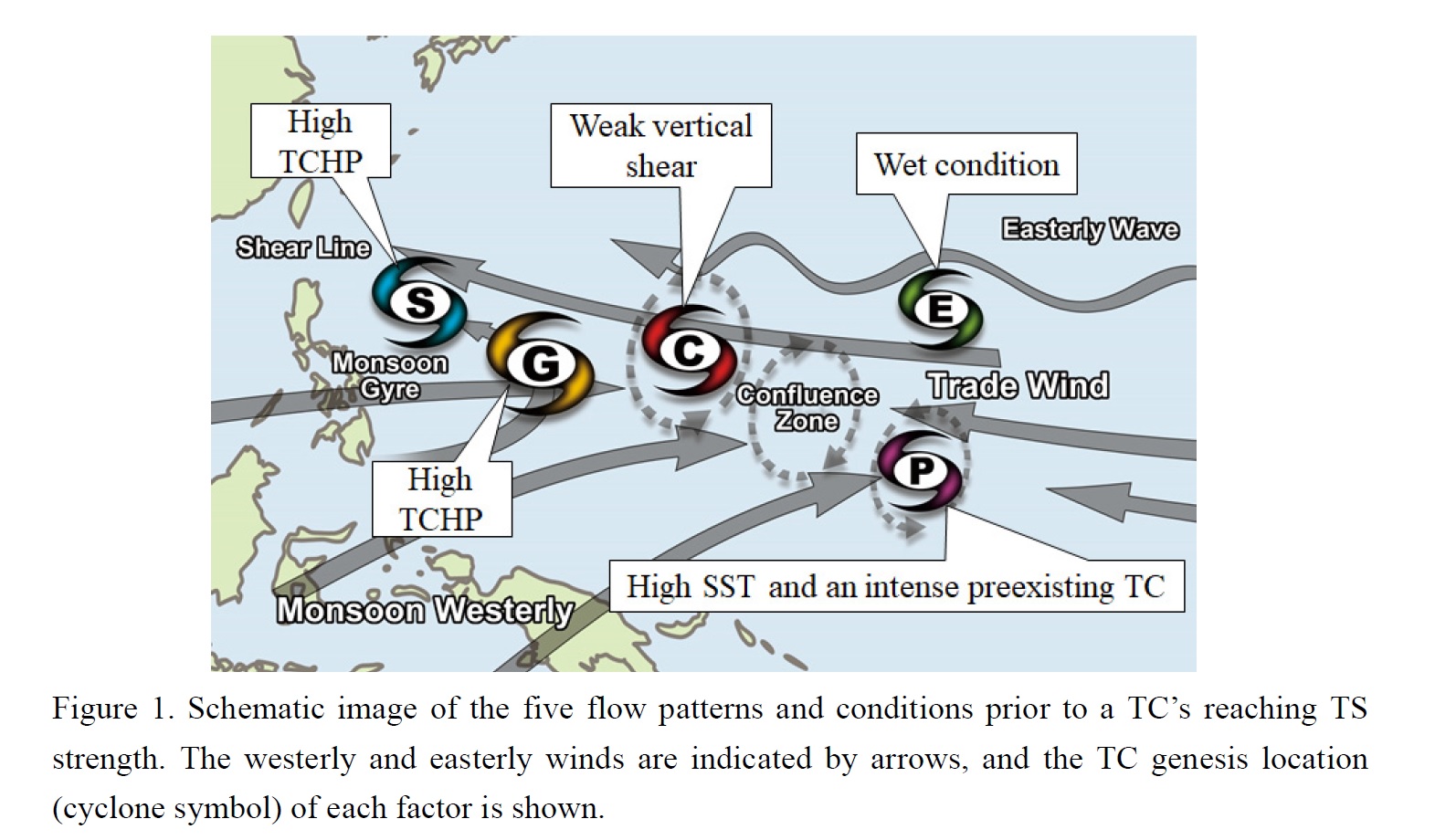
Fudeyasu et al. (2020)
Fudeyasu, H., R. Yoshida, M. Yamaguchi, H. Eito, C. Muroi, S. Nishimura, K. Bessho, Y. Oikawa, and N. Koide, 2020: Development conditions for tropical storms over the western North Pacific stratified by large-scale flow patterns. J. Meteor. Soc. Japan, 98, 61-72.
https://doi.org/10.2151/jmsj.2020-004
Graphical Abstract
Plain Language Summary: This study investigated the characteristics and environmental conditions of tropical cyclones (TCs) over the western North Pacific from 2009 to 2017 that dissipated before reaching tropical storm strength (TDs) under unfavorable environmental conditions; we compared these with TCs that reached tropical storm strength (TSs) in terms of modulations of relevant large-scale flow patterns. The flow patterns were categorized based on five factors: shear line (SL), confluence region (CR), monsoon gyre (GY), easterly waves (EW), and Rossby wave energy dispersion from a preexisting cyclone (PTC). Among 476 cases, 263 TDs were detected using best-track data and early stage Dvorak analysis.
Highlights:
- The environments around TDs were less favorable for development than those of TSs, as there were significant differences in atmospheric (oceanic) environmental parameters between TDs and TSs in the factors of CR, EW, and PTC (SL, GY, and PTC).
- The environmental conditions for reaching tropical storm strength using five factors can be summarized as follows: higher tropical cyclone heat potential in the SL and GY, weak vertical shear in the CR, wet conditions in the EW, and higher sea surface temperatures (SST) and an intense preexisting cyclone in the PTC.
Articles
Hohenegger et al. (2020)
Hohenegger, C., L. Kornblueh, D. Klocke, T. Becker, G. Cioni, J. F. Engels, U. Schulzweida, and B. Stevens, 2020: Climate statistics in global simulations of the atmosphere, from 80 to 2.5 km grid spacing. J. Meteor. Soc. Japan, 98, 73-91.
Special Edition on DYAMOND: The DYnamics of the Atmospheric general circulation Modeled On Non-hydrostatic Domains
https://doi.org/10.2151/jmsj.2020-005
Graphical Abstract
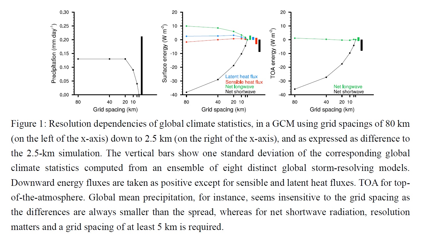
Plain Language Summary: General Circulation Models (GCMs) are complex tools embodying physical principles to represent the statistics of the climate system. Limitations in computer resources impose constraints on the resolution of such models and hence on the scales of the atmospheric processes that such models can explicitly represent. Both the chosen grid spacing and the employed model formulation affect the quality of a simulation. In this study, we examine the convergence behavior of a GCM by systematically varying its grid spacing. We objectively assess the convergence by comparing differences resulting from changes in grid spacing to differences resulting from using distinct model formulations. For the investigated statistics of the climate system, our study thus indicates at which grid spacing model formulation becomes more important than grid spacing.
Highlights:
- Forty-day global simulations have been performed with grid spacings down to 2.5 km and compared to an ensemble of eight distinct global storm-resolving models using kilometer-scale grid spacing.
- Using our convergence metric, we find that at least a grid spacing of 5 km is sufficient to capture 26 out of the 27 investigated climate statistics.
- Refining the grid spacing moves the simulations closer to observations, but climate statistics exhibiting weaker resolution dependencies are not necessarily associated with smaller biases.
Articles
Lin et al. (2020)
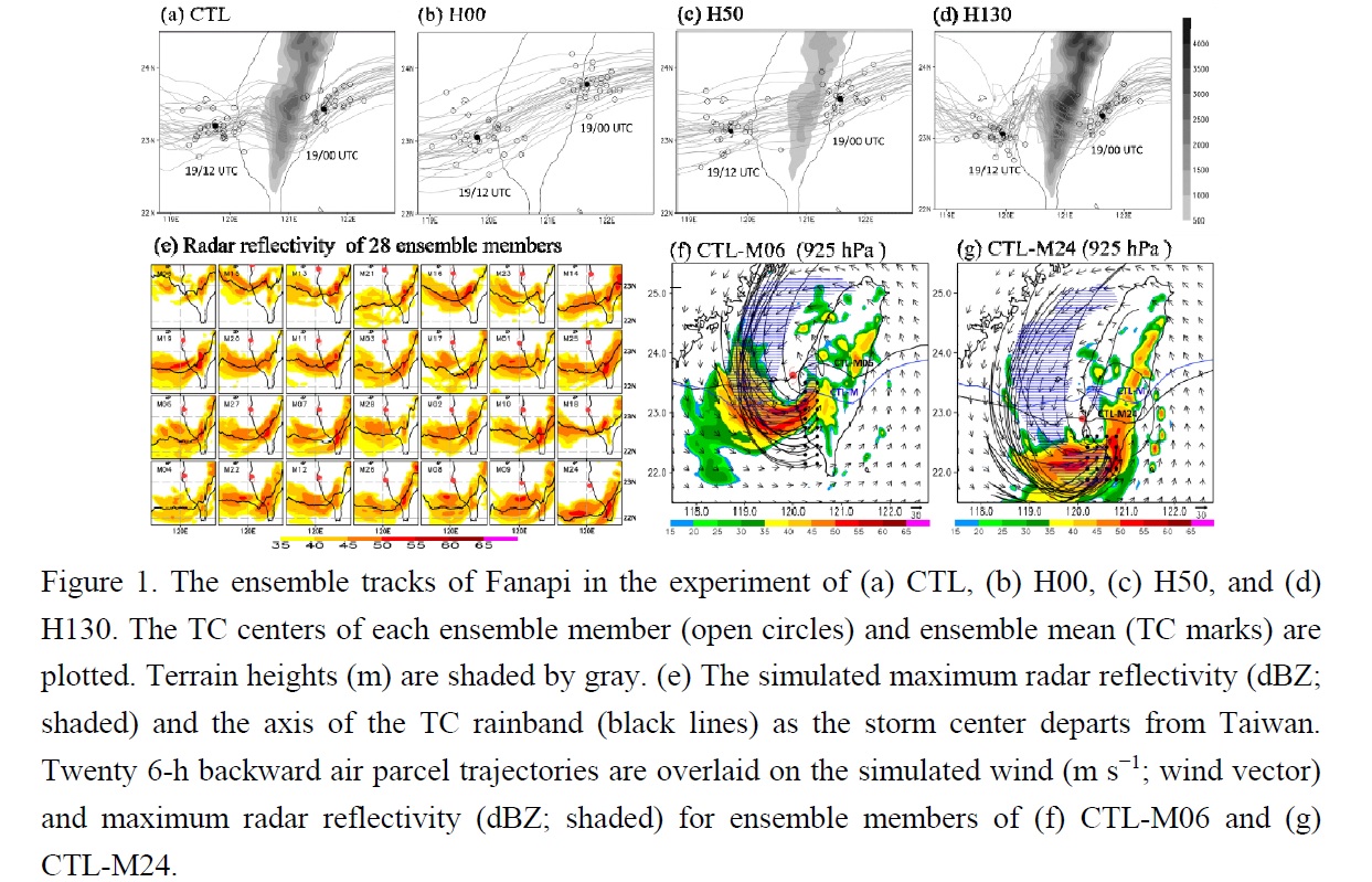
Lin, Y.-F., C.-C. Wu, T.-H. Yen, Y.-H. Huang, and G.-Y. Lien, 2020: Typhoon Fanapi (2010) and its interaction with Taiwan terrain - Evaluation of the uncertainty in track, intensity and rainfall simulations. J. Meteor. Soc. Japan, 98, 93-113.
https://doi.org/10.2151/jmsj.2020-006
Graphical Abstract
Plain Language Summary: Taiwan topography is considered a critical factor affecting the track, intensity, and rainfall for the landfalling tropical cyclone (TC), but the uncertainty of its impact in the simulations has not been thoroughly explored in the literature. Using an ensemble Kalman filter–based vortex initialization method, this paper evaluates the impact of Central Mountain Range (CMR) on the uncertainty in forecasting track, intensity, and rainfall of Typhoon Fanapi (2010) and explores the sources of the uncertainty in the simulation.
Highlights:
- The ensemble members with faster translation speed are influenced earlier by terrain and show an earlier southward track deflection and the weakening of intensity, resulting in a significant increase of uncertainty in track and intensity, especially in the experiments with higher terrain.
- The rainfall uncertainty in southern Taiwan is dominated by the uncertainty of the simulated TC rainband, and the latitude of the TC track can be regarded as a good predictor of the rainband’s location at departure time.
- The presence of Taiwan topography does not only change the characteristics of the simulated rainfall, but it also induces the asymmetric flow, which increases the variability in the location of the TC rainband and further affects rainfall uncertainty.
Articles
Umezawa et al. (2020)
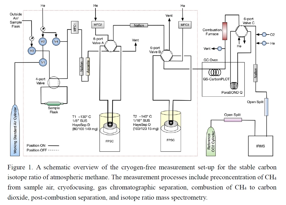
Umezawa, T., S. J. Andrews, and T. Saito, 2020: A cryogen-free automated measurement system of stable carbon isotope ratio of atmospheric methane. J. Meteor. Soc. Japan, 98, 115-127.
https://doi.org/10.2151/jmsj.2020-007
Graphical Abstract
Plain Language Summary: Methane (CH4) plays an important role in climate change and atmospheric chemistry. The stable carbon isotope ratio of atmospheric methane (δ13C-CH4) is useful for separating contributions of different CH4 source types. We set up a new measurement system for δ13C-CH4, optimized for the automated analysis of air samples. The system is operated with no use of cryogens (e.g., liquid nitrogen) and attained reproducibility sufficient to analyze atmospheric variations (~0.1‰). Automated continuous measurements of ambient air characterized imprint of local methane sources well. Future measurement operation will provide a large number of atmospheric δ13C-CH4 data.
Highlights:
- We set up a new cryogen-free measurement system for the stable carbon isotope ratio of atmospheric methane (δ13C-CH4) with reproducibility of ~0.1‰.
- Automated continuous measurements of ambient air characterized atmospheric δ13C-CH4 variations well.
- Future operation will provide a large number of atmospheric δ13C-CH4 data.
Articles
Miao et al. (2020)
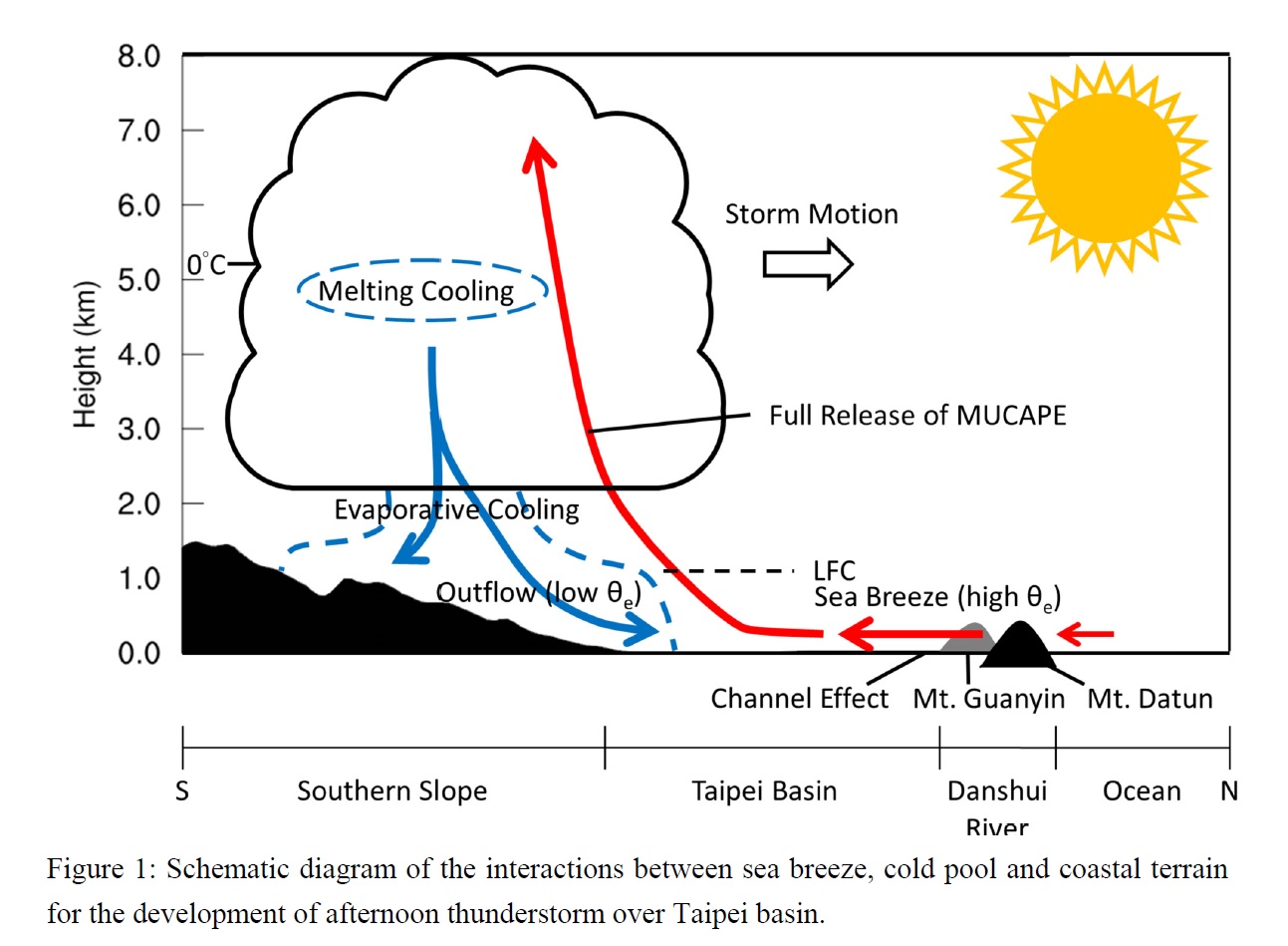
Miao, J.-E., and M.-J. Yang, 2020: A modeling study of the severe afternoon thunderstorm event at Taipei on 14 June 2015: The roles of sea breeze, microphysics, and terrain. J. Meteor. Soc. Japan, 98, 129-152.
https://doi.org/10.2151/jmsj.2020-008
Graphical Abstract
Plain Language Summary: On 14 June 2015, a severe afternoon thunderstorm event developed within the Taipei basin, producing intense rainfall (with rainfall rate of 131 mm h-1) and urban-scale flooding. This study uses high-resolution simulations (with the finest horizontal grid size of 500 m) to successfully reproduce this thunderstorm event, and performs numerical experiments to examine the interactions between sea breeze, cold-air outflow, and local coastal terrain of Mount Datun.
Highlights:
- Convective available potential energy (CAPE) was increased from 800 to 3200 J kg-1 with abundant moisture transport by the sea breeze from 08 to 12 LST.
- Evaporative cooling played a major role in the propagation of cold-air outflow and the production of heavy rainfall within Taipei basin, while melting cooling played a relatively minor role.
- Mount Datun at coastal region produced the channel effect through Danshui River Valley, intensified sea-breeze circulation and transported more moisture, made the thermodynamic characteristics more favorable for convection development, resulting in heavy rainfall.
Articles
Ha et al. (2020)
Ha, K.-J., J.-H. Yeo, Y.-W. Seo, E.-S. Chung, J.-Y. Moon, X. Feng, Y.-W. Lee, and C.-H. Ho, 2020: What caused the extraordinarily hot 2018 summer in Korea? J. Meteor. Soc. Japan, 98, 153-167.
Special Edition on Extreme Rainfall Events in 2017 and 2018
https://doi.org/10.2151/jmsj.2020-009
Graphical Abstract
Plain Language Summary: This study intends to diagnose an extraordinary heatwave (HW) in 2018 that the Korean Peninsula (KP) has experienced extreme heat throughout July and August with the highest temperature and longest consecutive hot days on record since 1907. The causes of these abnormal temperature patterns were examined with the difference from other episodic events as in 1994.
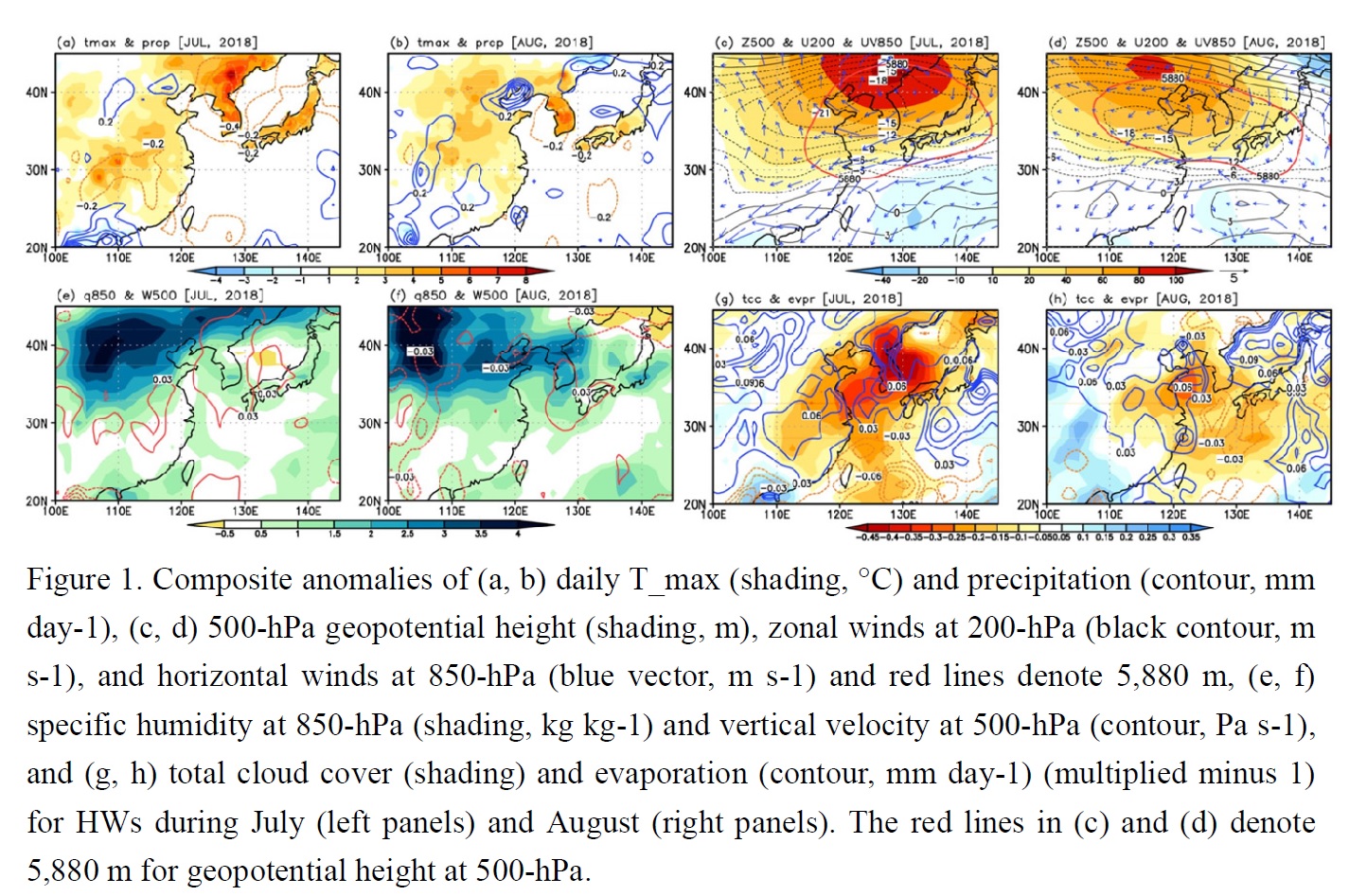
Highlights:
- The prolonged HWs in the KP is affected by the anticyclonic circulation related to the northern Pacific High (NPH) with abnormally less rainfall from July to August.
- The results suggest that a modon-like blocking with the northwestward expansion of NPH and a cyclonic anomaly in the east China Sea from July to August causes the strong static atmosphere in the mid-latitudes and seems to have played a crucial role.
- Low precipitation and massive evapotranspiration with the persistent insolation in July 2018 influenced the dry condition at the surface.
- Further studies on the northward expansion of the NPH and its association with jet streams are required in the context of vulnerability of HWs and the contribution of anthropogenic causes.
Articles
Takemura and Mukougawa (2020)
Takemura, K.,and H. Mukougawa, 2020: Dynamical relationship between quasi-stationary Rossby wave propagation along the Asian jet and Pacific-Japan pattern in boreal summer. J. Meteor. Soc. Japan, 98, 169-187.
https://doi.org/10.2151/jmsj.2020-010
Graphical Abstract
Plain Language Summary: To reveal a new possible process linking the quasi-stationary Rossby wave propagation over Eurasia along the Asian jet and the Pacific-Japan (PJ) pattern through the Rossby wave breaking (RWB) east of Japan during boreal summer, this study conducts a lag composite analysis of the past 44 RWB events. The results of this paper show that the quasi-stationary Rossby wave propagation along the Asian jet can excite the PJ pattern, through high potential vorticity (PV) intrusion toward the subtropical western North Pacific associated with the RWB and the consequent enhanced convection over the region.
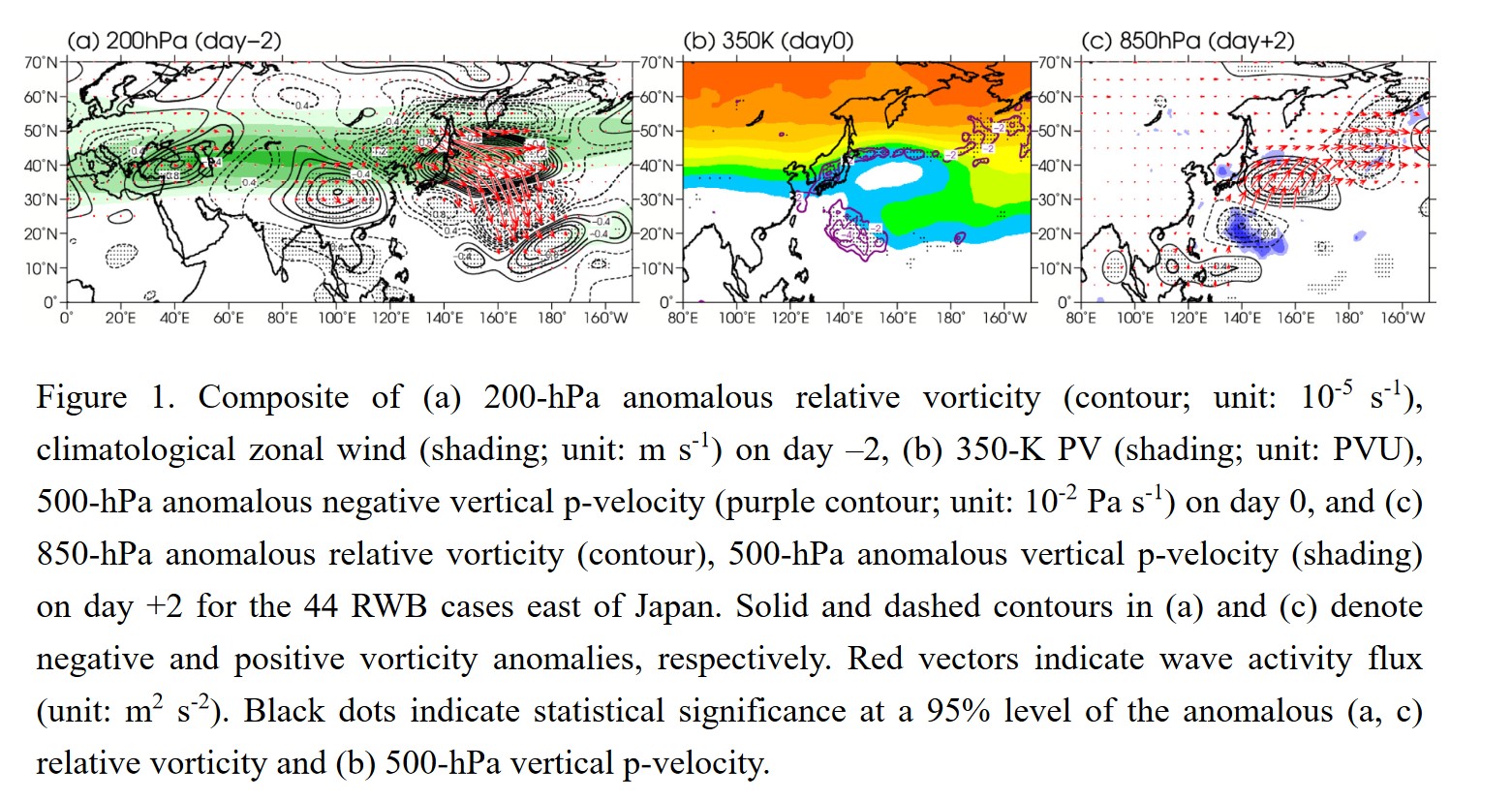
Highlights:
- The lag composite analysis shows that the quasi-stationary Rossby wave propagation along the Asian jet induces the “inverse-S” shaped RWB east of Japan, the associated southwestward high-PV intrusion toward the subtropical western North Pacific and the consequent enhanced convection over the region, which in turn excites the subsequent PJ pattern.
- Q-vector diagnosis and vorticity budget analysis show an essential contribution of the high-PV intrusion to the enhanced convection over the subtropical western North Pacific, through dynamically induced ascent.
- A partial correlation analysis quantitatively shows greater contribution of the high-PV intrusion to the enhanced convection over the subtropical western North Pacific and the formation of the PJ pattern, compared to the anomalous warm sea surface temperature condition over the region.
Articles
Tomita et al. (2020)
Tomita, T., T. Shirai, and T. Yamaura, 2020: Effects of the Australian winter monsoon on the persistence of La Niña events. J. Meteor. Soc. Japan, 98, 189-211.
https://doi.org/10.2151/jmsj.2020-011
Graphical Abstract
Plain Language Summary: La Niña (LN) events generally persist longer than El Niño (EN) events. This study revealed that the anomalous Australian winter monsoon (AWM) maintains LN events long through strengthening the convective activity in and around the Indonesian maritime continent (IMC) from March to August (Figure 1). First, LN forces the surface temperature in the northern Australian continent (NAC) low by modifying surface soil moisture and downward shortwave radiation flux there. Formed large surface temperature difference between the IMC and the NAC drives the stronger-thanusual AWM, which maintains LN events long. LN seems to have a self-sustained mechanism with a positive feedback with the AWM, which may be called the LN-AWM feedback. EN does not have such a feedback mechanism so that EN events end in the period of March–August.
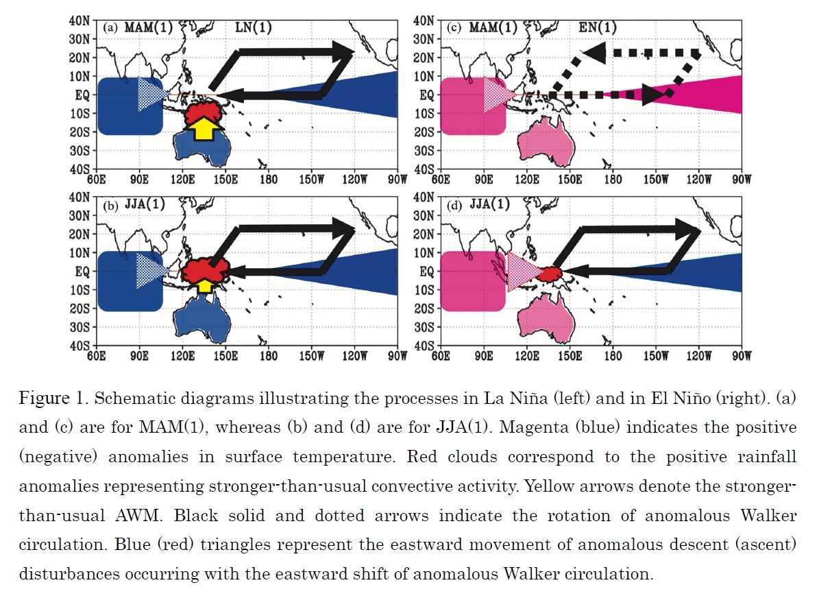
Highlights:
- A physical mechanism maintaining La Niña events long is proposed; that is the anomalous Australian winter monsoon.
- La Niña modifies the Australian winter monsoon to be stronger-than-usual.
- La Niña has a self-sustained mechanism with a positive feedback with the Australian winter monsoon.
Articles
Li et al. (2020)
Li, Z., Y. Luo, Y. Du, and J. C. L. Chan, 2020: Statistical characteristics of pre-summer rainfall over South China and associated synoptic conditions. J. Meteor. Soc. Japan, 98, 213-233.
https://doi.org/10.2151/jmsj.2020-012
Graphical Abstract
Plain Language Summary: After the South China Sea (SCS) monsoon onset, an increase in domain-averaged rainfall accumulation and a generally enhanced convective intensity over South China (SC) during Apr-Jun were previously noticed. This study comparatively examines the characteristics of rainfall over the west-inland, east-inland, and coastal regions of SC during pre- and post-monsoon onset periods, and discuss the associated synoptic conditions and physical mechanisms.
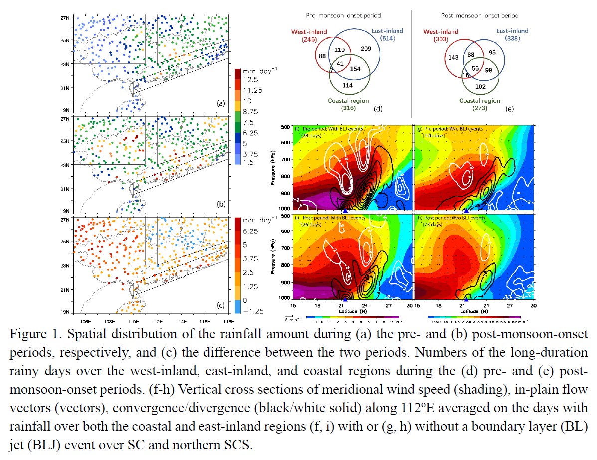
Highlights:
- After the monsoon onset, accumulated rainfall amounts increase over the west-inland and coastal regions, whereas remain nearly unchanged in the east-inland region due to its enhanced intensity but fewer occurrences of rainfall.
- Favorable dynamic instability and thermodynamic conditions for the inland rainfall result from collective effects of a subtropical low pressure/front/shearline and southwesterly air flow of tropical origin.
- The deceleration of the southerly BL flow over the northern SCS leads to convergence of BL high-θe air near the coast, which is a key factor in producing the coastal, warm-sector rainfall. However, heavy rainfall could occur near the coast even the southerly air flows in the BL and lower troposphere are too weak to be considered as jets.
Articles
Yokoyama et al. (2020)
Yokoyama, C., H. Tsuji, and Y. N. Takayabu, 2020: The effects of an upper-tropospheric trough on the heavy rainfall event in July 2018 over Japan. J. Meteor. Soc. Japan, 98, 235-255.
Special Edition on Extreme Rainfall Events in 2017 and 2018
https://doi.org/10.2151/jmsj.2020-013
Graphical Abstract
Plain Language Summary: Heavy rainfall occurred over a broad portion of western Japan on July 5–8, 2018. We found that the heavy rainfall was brought by a well-organized rainfall system, which was maintained under relatively stable and very humid conditions compared with the climatology. An upper-tropospheric trough, which lingered around the Korean Peninsula, played an important role in producing the humid stratification. By examining dynamical ascent associated with the trough and diabatic ascent separately, we found that dynamical ascent helped to moisten a relatively deep layer of the mid- to lower troposphere in conjunction with southerly horizontal moisture flux.
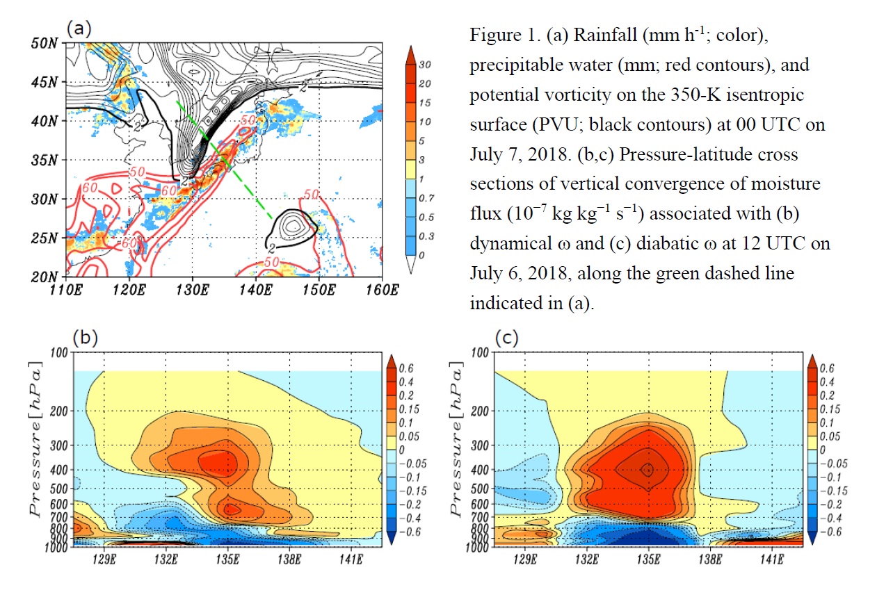
Highlights:
- The heavy rainfall, which occurred across an extensive area of Japan on July 5–8, 2018, was brought by a well-organized rainfall system with both intense convective rainfall and a large area of stratiform rainfall.
- The large-scale environments related to the event were relatively stable and very humid throughout most of the troposphere compared with the climatology.
- Dynamical ascent associated with an upper-tropospheric trough helped to maintain an environment favorable for rainfall organization thorough the moistening of the mid-troposphere.
JMSJ, 2020, Vol. 98, No. 2 (April)
Review Articles
Sui et al. (2020)
Sui, C.-H., M. Satoh, and K. Suzuki, 2020: Precipitation efficiency and its role in cloud-radiative feedbacks to climate variability. J. Meteor. Soc. Japan, 98, 261-282.
https://doi.org/10.2151/jmsj.2020-024
Graphical Abstract
Plain Language Summary: This is a review for studies of cloud and climate from the perspective of Precipitation Efficiency (PE) that is a measure of the portion of total condensation rate in a convective system that is converted into precipitation flux at the surface. PEs have been defined and estimated from microscopic and macroscopic perspectives. We review these studies for various types and systems of convection using observational and modeling approaches. We also review studies about key cloud physical processes in shallow and deep convection and cloud-radiation changes with climate warming in view of PE.
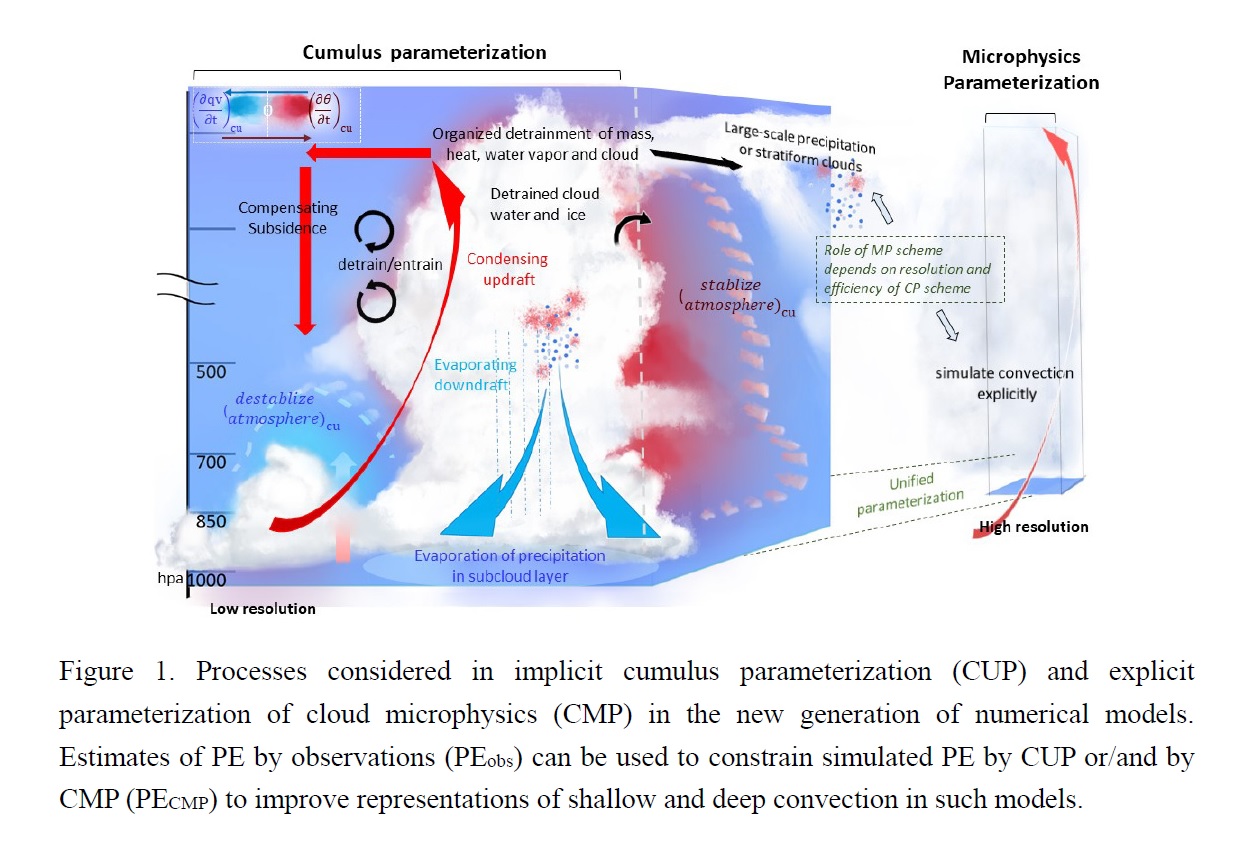
Highlights:
- PEobs : thunderstorms in North America (0.1~0.6); tropical and subtropical squall lines (0.45–0.57); tropical convective and stratiform convection (~0.7, ~2.0); trade wind clouds (0.2–0.3);
- PECMP: tropical cumulus (0.2–0.8); cumulus congestus (0.3–0.5), tropical and mid-latitude squall systems (0.2–0.5), hurricanes/typhoons (0.6–0.75 over ocean, 0.95 over steep mountain), mixed-phase mid-latitude convection (~0.2).
- PE is an important physical constraint in parameterized cloud physics.
- Roles of PE on high- and low-clouds and their changes are discussed.
- PE is useful in understanding cloud-precipitation changes in studies of climate projection.
Articles
Chen et al. (2020)
Chen, W., Z. Guan, H. Yang, and Q. Xu, 2020: East Asian-Australian monsoon variations and their impacts on regional climate during boreal summer. J. Meteor. Soc. Japan, 98, 283-297.
https://doi.org/10.2151/jmsj.2020-014
Graphical Abstract
Plain Language Summary: The East Asian summer monsoon (EASM) and the Australian winter monsoon (AWM) are two important components of the Asian-Australian monsoon system during boreal summer. Our results demonstrate that AWM and EASM are closely related to each other even after ENSO and IOD signals are filtered out. When the Australian winter monsoon is anomalously strong, the cold Australian High and the WPSH both intensify and the East Asian summer monsoon becomes stronger to the south of 30oN. The simultaneous variations of these two monsoons would have remarkable impacts on climate in the Asian-Australian region.
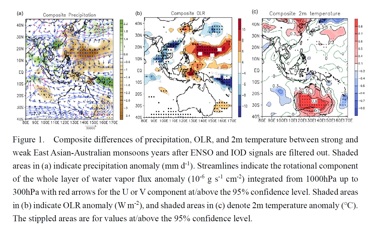
Highlights:
- The anomalously strong (weak) EAAMs correspond to anomalously strong (weak) AWM and EASM to the south of 30°N. Such simultaneous changes of the monsoons and related circulation systems are associated with SST anomalies in the equatorial Pacific.
- The EASM couples with AWM via the anomalous easterlies near equator in the Maritime Continent (MC) region and the slanted vertical anomalous circulations.
- In the years with strong EAAMs, precipitation decreases in northern Australia and over areas from the western Pacific to Bohai Sea and Yellow Sea of China. Meanwhile, the western MC and the southeastern China experience more than normal precipitation.
Articles
Jayalakshmi et al. (2020)
Jayalakshmi, J., B. K. Seela, P.-L. Lin, P. K. Wang, C.-H. Tseng, K. K. Reddy, H. Hashiguchi, L. Feng, S. K. Das, and C. K. Unnikrishnan, 2020: Raindrop size distribution characteristics of Indian and Pacific Ocean tropical cyclones observed at India and Taiwan sites. J. Meteor. Soc. Japan, 98, 299-317.
https://doi.org/10.2151/jmsj.2020-015
Graphical Abstract
Plain Language Summary: For the first time, we investigated the raindrop size distribution (RSD) characteristics of the Indian Ocean and Pacific Ocean tropical cyclones (TCs) using ground-based Parsivel disdrometer measurements in south India and south Taiwan observational sites, respectively. Disdrometers observations show that the mid-size and large drops were more in number in the Pacific Ocean TCs than the Indian Ocean TCs, and these two oceanic TCs showed significant differences in RSD empirical relations (Dm-R, log10Nw-R, μ-Λ Dm-σm , log10Nw-Dm , and Z-R ). Relatively a higher convective activity and water vapor in the Pacific Ocean TCs than the Indian Ocean TCs resulted in distinct RSD features between the two oceanic TCs through different microphysical processes.
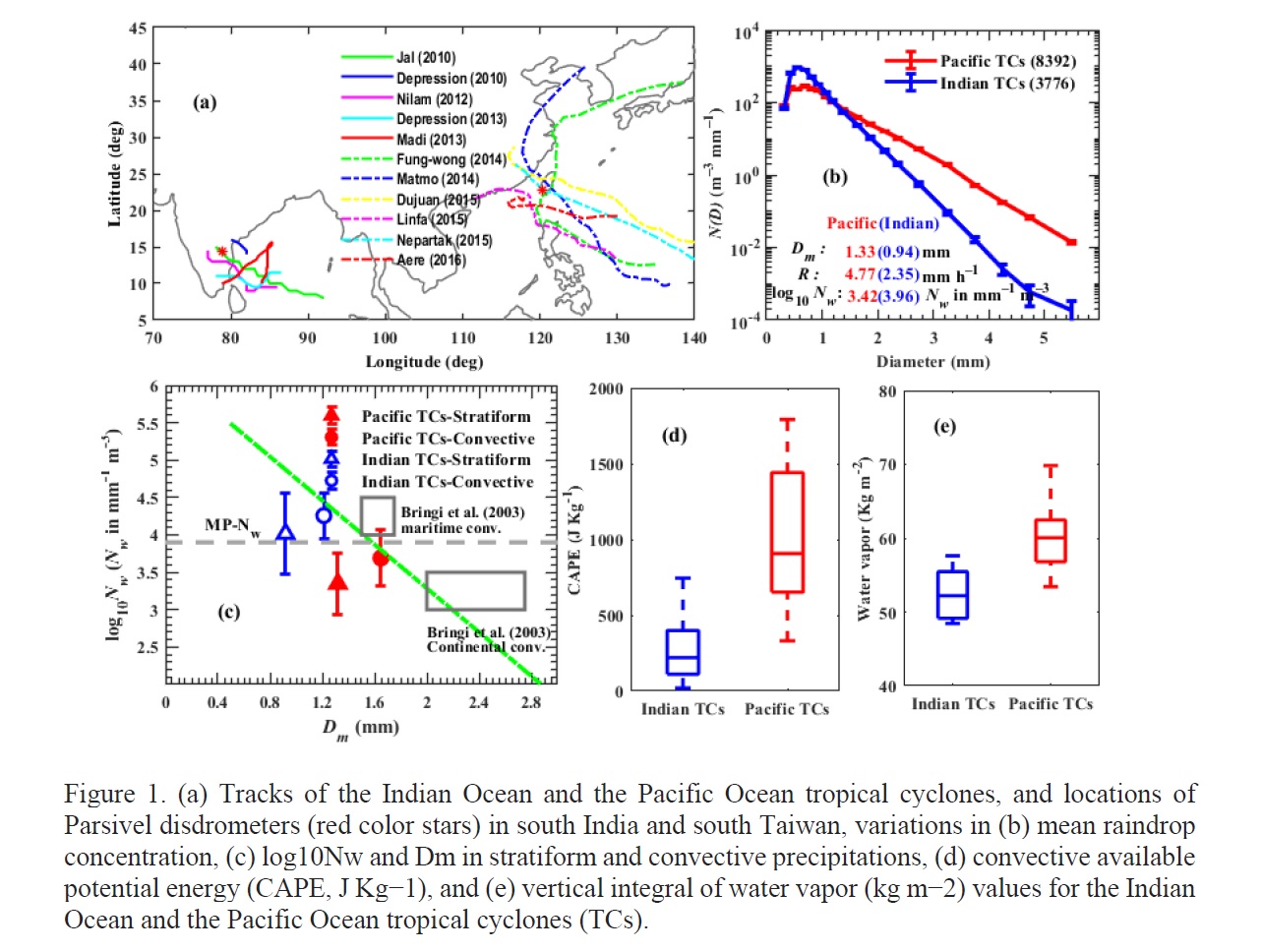
Highlights:
- For the first time, raindrop size distribution (RSD) features of the Indian Ocean and the Pacific Ocean tropical cyclones (TCs) are documented using ground-based disdrometers, remote sensing, and, reanalysis data sets.
- RSD stratified based on rainfall rate and precipitation types showed a large number of mid-size and large drops and less number of small drops in the Pacific Ocean TCs than the Indian Ocean TCs.
- Current study confirm that we must adopt TC-specific empirical relations in remote sensing and radar rainfall estimation algorithms.
Articles
Aono et al. (2020)
Aono, K., T. Iwasaki, and T. Sasai, 2020: Effects of wind-evaporation feedback in outer regions on tropical cyclone development. J. Meteor. Soc. Japan, 98, 319-328.
https://doi.org/10.2151/jmsj.2020-017
Graphical Abstract
Plain Language Summary: Tropical cyclone (TC) intensification is widely understood according to the wind-evaporation feedback. In the conventional framework, many authors have discussed the increase of sea surface evaporation as the surface wind increases near the eyewall. On the other hand, we discuss the surface evaporation decrease as the wind speed decreases in the outer region. Idealized numerical experiments showed that the increased surface evaporation in the outer region significantly weakens the TC and reduces its size. The radial contrast is suggested to have more importance for the TC organization than the water vapor mixing ratio itself. This is a very different interpretation of the wind-evaporation feedback on TC development from the conventional idea.
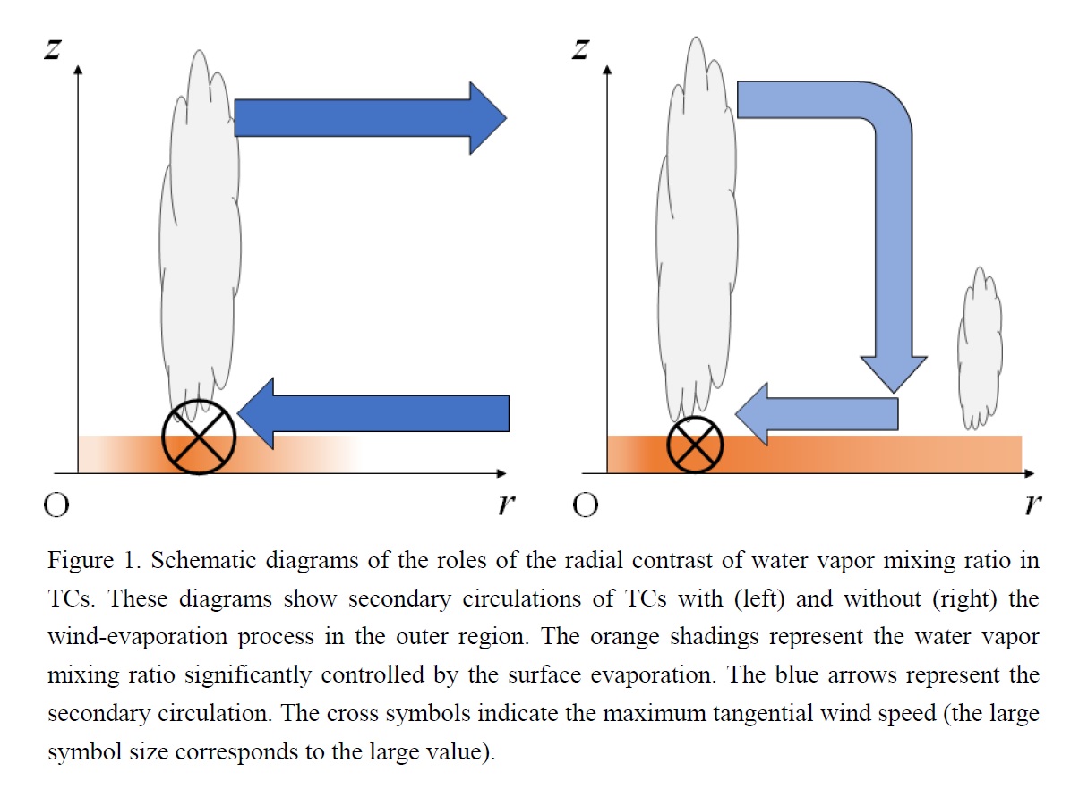
Highlights:
- The experiments set a lower limit of wind speed used in the parameterization of evaporation coefficient from the sea surface to suppress the wind-evaporation feedback in the outer region.
- Although the modified scheme significantly increases water vapor mixing ratio in the outer region of TCs, it weakens TCs, reduces their sizes, and delays the onset of rapid intensification.
- The findings suggest that the formation of radial contrast of water vapor concentration is vital for the wind-evaporation feedback in the TC organization.
Articles
Tomita and Yamaura (2020)
Tomita, T., and T. Yamaura, 2020: Interannual variability of Baiu frontal activity in May and its connectivity with June. J. Meteor. Soc. Japan, 98, 329-351.
https://doi.org/10.2151/jmsj.2020-018
Graphical Abstract
Plain Language Summary: The Baiu front (BF) is climatologically formed in May in the western North Pacific. This study investigated the interannual variability of Baiu frontal activity (BFA) in May (BFA-M) and its connectivity with June. First, an anomalous circulation centered around Taiwan, which is interpreted as a moist Rossby wave from the equatorial Kelvin–Rossby wave packet, controls the interannual variability with modifying southerlies from the tropics (Fig. 1). Second, a biennial tendency characterizes the interannual variability of BFA-M with a tripole SSTA pattern and anomalous Walker circulations in the tropical Pacific (Fig. 2), both of which are suitable for confining the disintegration of the equatorial Kelvin–Rossby wave packet in the western Pacific and guiding the northwestward propagation of the moist Rossby wave. With the phase reversal of this moist Rossby wave, the biennial tendency remains in the western part of the BF from May to mid-June.
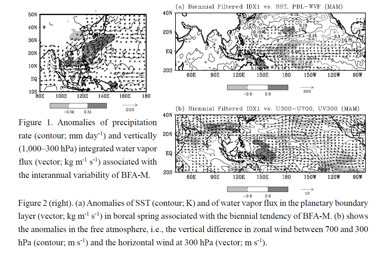
Highlights:
- An anomalous large-scale circulation centered around Taiwan, which is identified as a moist Rossby wave, modifies BFA-M.
- The moist Rossby wave is emanated from the equatorial Kelvin–Rossby wave packet in the western Pacific.
- A biennial tendency characterizes the interannual variability of BFA-M with a tripole SSTA pattern and corresponding anomalous Walker circulations in the tropical Pacific.
Articles
Naoe et al. (2020)
Naoe, H., T. Matsumoto, K. Ueno, T. Maki, M. Deushi, and A. Takeuchi, 2020: Bias correction of multi-sensor total column ozone satellite data for 1978-2017. J. Meteor. Soc. Japan, 98, 353-377.
https://doi.org/10.2151/jmsj.2020-019
Graphical Abstract
Plain Language Summary: In this study, we have constructed a merged dataset using 20 available satellite Level 2 total column ozone (TCO) datasets over 40 years from 1978 to 2017. The individual datasets and the merged dataset are corrected against selected Dobson and Brewer spectrophotometer TCO measurements by two methods: simple linear regression (SLR) as a function of time, and multiple linear regression (MLR) as a function of time, solar zenith angle, and effective ozone temperature.
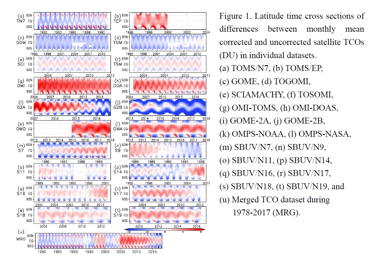
Highlights:
- The behavior of the merged TCO after bias correction by SLR is similar to that after correction by MLR.
- The root mean square of TCO overpass differences in the corrected datasets by SLR and MLR are reduced from 8.6 DU to 8.4 DU.
- The corrected merged TCO datasets that are converted into time-series homogenization with high temporal-resolution are suitable as a data source for trend analyses as well as assimilation for long-term reanalysis.
Articles
Yang et al. (2020)
Yang, H., L. Wu, and T. Xie, 2020: Comparisons of four methods for tropical cyclone center detection in a high-resolution simulation. J. Meteor. Soc. Japan, 98, 379-393.
https://doi.org/10.2151/jmsj.2020-020
Graphical Abstract
Plain Language Summary: Detecting tropical cyclone (TC) centers is a challenge in understanding TC inner-core dynamics. Four frequently used center detecting methods are evaluated in a highresolution simulation of Hurricane Wilma (2005). The vertical tilt the minimum pressure variance center (MVC) and the potential vorticity centroid center (PVC) are generally smooth, while the relative tracks of the maximum tangential wind center (MTC) and the pressure centroid center (PCC) contain abrupt changes. The MVC also leads to the strongest symmetric structure in the tangential wind, PV, and radial PV gradient in the eyewall region. This study suggests that the MVC should be selected in the study of inner-core processes.
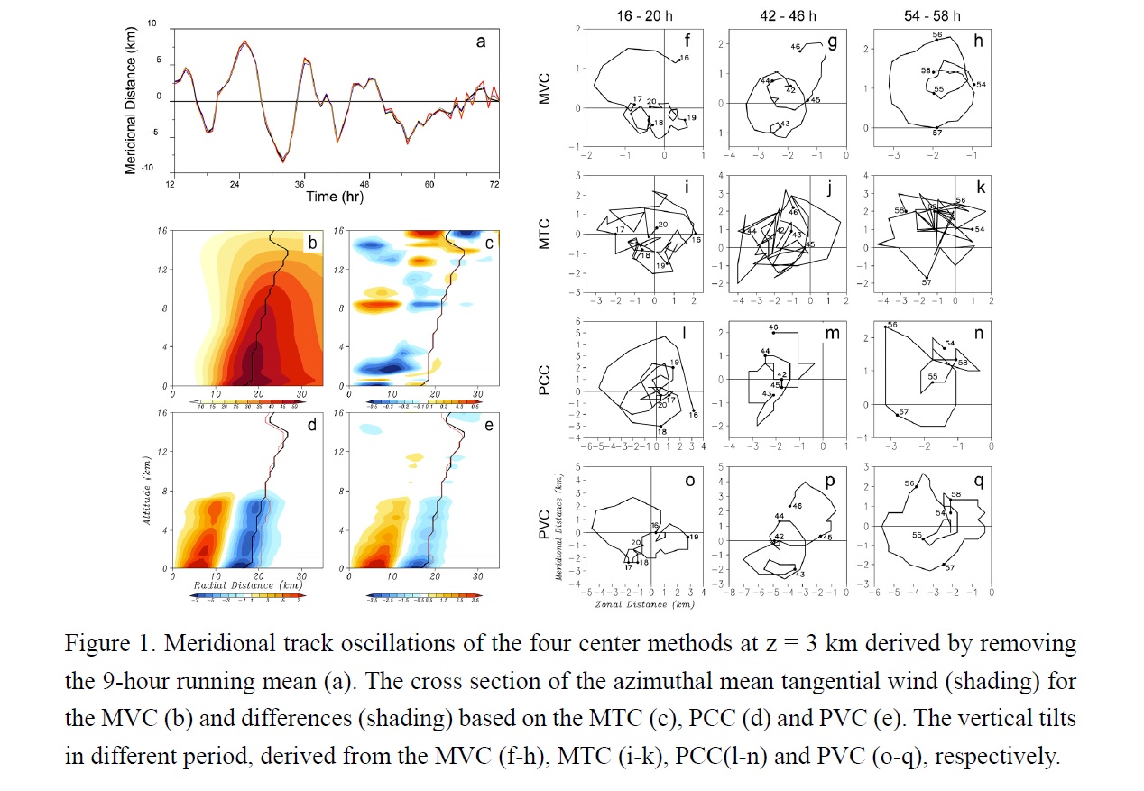
Highlights:
- By using a high-temporal-spatial-resolution simulated hurricane, four TC center detecting methods are evaluated.
- The differences in the detected center position and vertical tilt are generally small due to the strong TC intensity, with similar small-scale track oscillations that rotate cyclonically around the mean track.
- The MVC shows the smoothest track and vertical tilt, also leads to the strongest symmetric structure in the tangential wind, PV, and radial PV gradient in the eyewall region, therefore it is recommended in the study of inner-core processes.
Articles
Stevens et al. (2020)
Stevens, B., C. Acquistapace, A. Hansen, R. Heinze, C. Klinger, D. Klocke, H. Rybka, W. Schubotz, J. Windmiller, P. Adamidis, I. Arka, V. Barlakas, J. Biercamp, M. Brueck, S. Brune, S. A. Buehler, U. Burkhardt, G. Cioni, M. Costa-Suròs, S. Crewell, T. Crüger, H. Deneke, P. Friederichs, C. C. Henken, C. Hohenegger, M. Jacob, F. Jakub, N. Kalthoff, M. Köhler, T. W. van Laar, P. Li, U. Löhnert, A. Macke, N. Madenach, B. Mayer, C. Nam, A. K. Naumann, K. Peters, S. Poll, J. Quaas, N. Röber, N. Rochetin, L. Scheck, V. Schemann, S. Schnitt, A. Seifert, F. Senf, M. Shapkalijevski, C. Simmer, S. Singh, O. Sourdeval, D. Spickermann, J. Strandgren, O. Tessiot, N. Vercauteren, J. Vial, A. Voigt, and G. Zängl, 2020: The added value of large-eddy and storm-resolving models for simulating clouds and precipitation. J. Meteor. Soc. Japan, 98, 395-435.
Special Edition on DYAMOND: The DYnamics of the Atmospheric general circulation Modeled On Non-hydrostatic Domains
https://doi.org/10.2151/jmsj.2020-021
Graphical Abstract
Plain Language Summary: This study investigates, if atmospheric models with horizontal resolutions of 100 m to 2 km are able to better simulate key features, like clouds and precipitation, of the climate system than currently used models employing much coarser resolution and parameterized convection. Precipitation characteristics are much more realistic in the simulations with explicitly convection, already at kilometer resolutions. Increasing resolution to hectometer scales improves the simulation of precipitation only modestly, but substantially improves the simulation of clouds. The results suggest that new climate models, which explicitly resolve convection and the interaction with its environment, offer exciting opportunities to learn about the climate system.
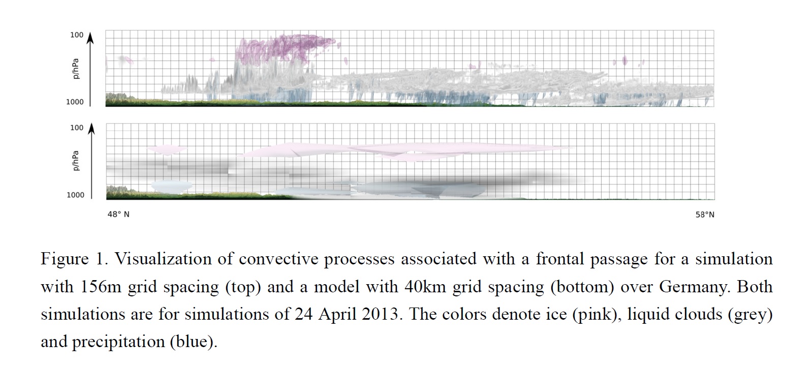
Highlights:
- In almost every respect, the representation of the vertical motion leads to an improved, and more physical, representation of clouds and precipitation as compared to models using parameterizations to represent clouds and convective processes.
- Most improvements for precipitations statistics are already achieved at kilometer scale resolutions, compared to models using parameterized convection.
- The representation of clouds improves further, when increasing resolutions to hectometer scales.
Articles
Miyamoto et al. (2020)
Miyamoto, Y., S. Nishizawa, and H. Tomita, 2020: Impacts of number of cloud condensation nuclei on two-dimensional moist Rayleigh convection. J. Meteor. Soc. Japan, 98, 437-453.
https://doi.org/10.2151/jmsj.2020-023
Graphical Abstract
Plain Language Summary: The impacts of number of cloud condensation nuclei (CCN) on moist Rayleigh convection were examined by using a simple 2D fluid model with a double moment microphysics model. The effect is most prominent in the initially formed convection, whereas the convection in the quasi-steady state does not significantly depend on the number of CCN. It is suggested that the former convection forms by local buoyancy, while the latter is largely influenced by boundaries.
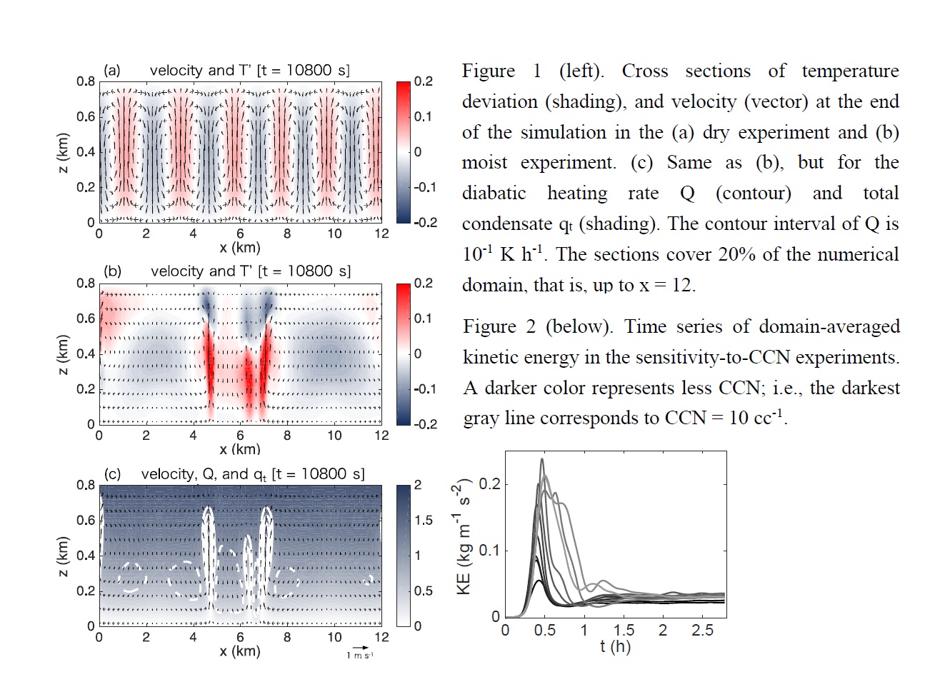
Highlights:
- The number of CCN affects convective cells initially formed in simulations, whereas the cells during the quasi-steady state are not sensitive.
- The overall impacts of incorporating a double-moment cloud microphysics are to reduce the integrated kinetic energy and number of convective cells (increase the distance between the cells).
Notes and Correspondence
Duc et al. (2020)
Duc, L., K. Saito, and D. Hotta, 2020: An explanation for the diagonally predominant property of the positive symmetric ensemble transform matrix. J. Meteor. Soc. Japan, 98, 455-462.
https://doi.org/10.2151/jmsj.2020-022
Graphical Abstract
Plain Language Summary: The ensemble transform matrix T in the Ensemble Transform Kalman Filter is observed to have the diagonally predominant property, i.e. the diagonal terms are at least an order of magnitude larger than the off-diagonal terms, but why it possesses such a property has not been well understood. This property has shown to have a close connection to the fact that T is the closest matrix to a scalar multiple of the identity I. This fact reveals that T can be decomposed into a sum of a diagonal matrix D and a full matrix P whose Frobenius norms are proportional, respectively, to the mean and the standard deviation of the spectrum of T. In general cases, these norms are not much different but the fact that the number of non-zero elements of P is the square of ensemble size while that of D is the ensemble size causes the large difference in the orders of elements of P and D.
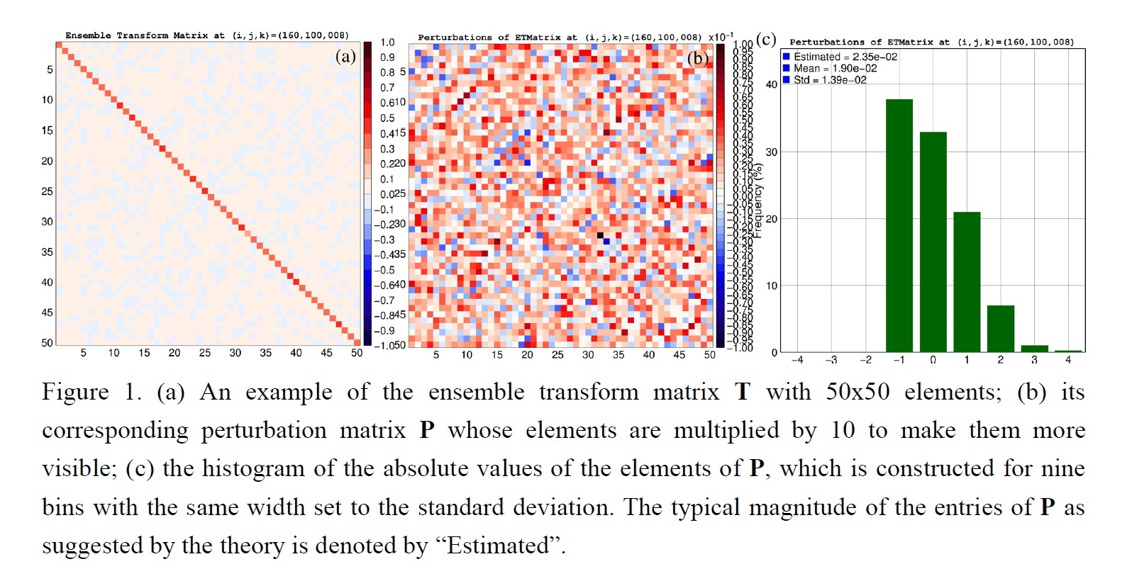
Highlights:
- T is proved to be the closest matrix to the identity I in the sense of the Frobenius norm among all valid ensemble transform matrices. This property has been stated but never proved in the data assimilation literature.
- T is also proved to be the closest matrix to a scalar multiple of I. The scalar multiple of I closest to T in this case is aI where a is the average of the eigenvalues of T.
- The diagonally predominant property is only an empirical fact and not an inherently mathematical property of T. Violations of this property are rarely observed in practice since their occurrences require an unrealistic situation where background errors are larger than observation errors by at least two orders of magnitude.
Notes and Correspondence
Geng et al. (2020)
Geng, B., M. Katsumata, and K. Taniguchi, 2020: Modulation of the diurnal cycle of precipitation near the southwestern coast of Sumatra by mixed Rossby-gravity waves. J. Meteor. Soc. Japan, 98, 463-480.
Special Edition on Years of the Maritime Continent (YMC)
https://doi.org/10.2151/jmsj.2020-026
Graphical Abstract
Plain Language Summary: The impact of mixed Rossby-gravity waves (MRGWs) on the diurnal cycle of precipitation over the southwestern coastal area of Sumatra was investigated using data captured during a pilot field campaign of the Years of the Maritime Continent (YMC) project. The results suggest that local convergence induced by the land–sea contrast is mainly responsible for driving the diurnal cycle. Notwithstanding, MRGWs exert a significant impact on the amplitude of diurnal convection and precipitation by modulating the dynamic structure of the atmosphere.
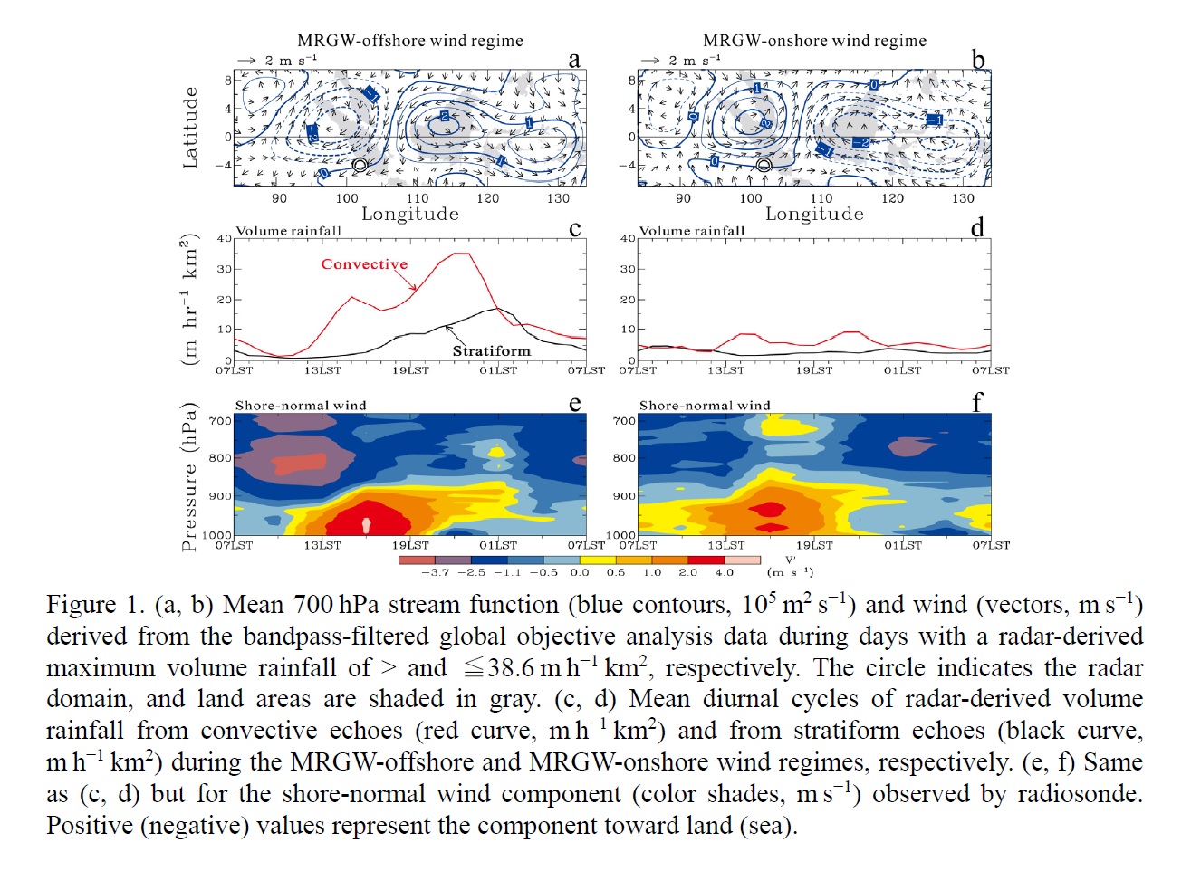
Highlights:
- Diurnal convection and precipitation over the land and ocean were enhanced (suppressed) when MRGW-induced offshore (onshore) wind perturbations dominated over the radar domain.
- Stronger large-scale low-level convergence and more intense sea- and land-breeze circulations were observed with the intensification of MRGW-induced offshore wind perturbations.
- However, diurnal precipitation displayed a similar well-defined phase, coherent with the regular evolution of sea- and land-breeze circulations, regardless of wind perturbations induced by MRGWs.
JMSJ, 2020, Vol. 98, No. 3 (June)
Review Articles
Kato (2020)
Kato, T., 2020: Quasi-stationary band-shaped precipitation systems, named “senjo-kousuitai”, causing localized heavy rainfall in Japan. J. Meteor. Soc. Japan, 98, 485-509.
https://doi.org/10.2151/jmsj.2020-029
Graphical Abstract
Plain Language Summary: Localized heavy rainfall events with 3-houly accumulated precipitation amounts larger than 200 mm are often observed in Japan. Such events are majorly brought from quasi-stationary band-shaped precipitation systems, named as “senjo-kousuitai” in Japanese. Senjo-kousuitai is defined as a band-shaped heavy rainfall area with the length of 50-300 km and the width of 20-50 km, produced by successively formed and developed convective cells, lining up to organize multi-cell clusters, and passing or stagnating at almost the same place for a few hours.
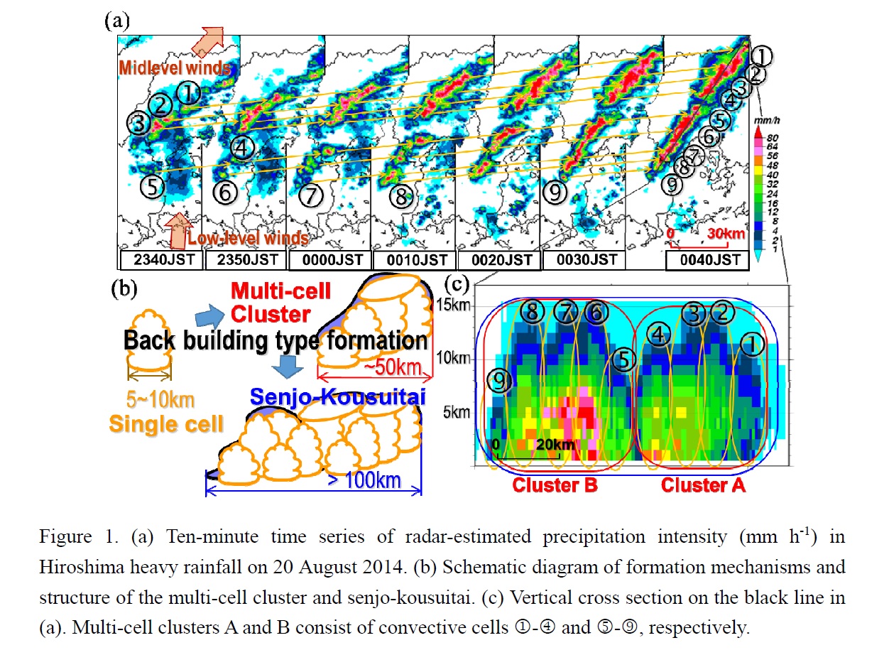
Highlights:
- This study reviewed previous studies of band-shaped precipitation systems, and also examined the numerical reproducibility of senjo-kousuitai events.
- Characteristics of senjo-kousuitai events are statistically studied based on distributions of 3-hourly accumulated precipitation amounts.
- Six favorable occurrence conditions of senjo-kousuitai events for their diagnostic forecasts were statistically constructed from environmental atmospheric fields in previous events.
Articles
Ma et al. (2020)
Ma, Y., V. Chandrasekar, and S. K. Biswas, 2020: A Bayesian correction approach for improving Dual-frequency Precipitation Radar rainfall rate estimates. J. Meteor. Soc. Japan, 98, 511-525.
Special Edition on Global Precipitation Measurement (GPM): 5th Anniversary
https://doi.org/10.2151/jmsj.2020-025
Graphical Abstract
Plain Language Summary: The accurate estimation of precipitation is an important objective for the Dual-frequency Precipitation Radar (DPR), which is located on board the Global Precipitation Measurement (GPM) satellite core observatory. This study proposes a Bayesian correction (BC) approach to improve the DPR’s instantaneous rainfall rate product, where ground dual-polarization radar (GR) observations are used as references. Rainfall intensities such as light, moderate, and heavy rain and their variable influences on the model’s performance are considered.
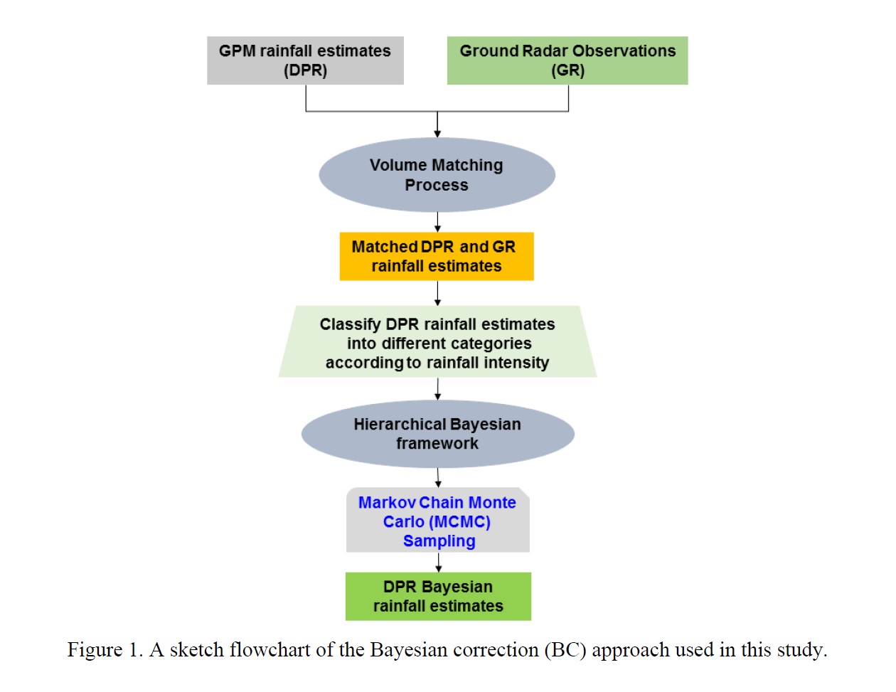
Highlights:
- A Bayesian correction (BC) approach based on a generalized regression model is proposed.
- Observation errors in the DPR instantaneous rainfall rate estimates are analyzed as a function of rainfall intensity.
- The experiment demonstrates that the DPR_BC rainfall rate estimates have superior skill scores and are in better agreement with the GR references than with the DPR estimates.
Articles
Cui et al. (2020)
Cui, Y., Z. Ruan, M. Wei, F. Li, and R. Ge, 2020: Vertical structure and dynamical properties during snow events in middle latitudes of China from observations by the C-band vertically pointing radar. J. Meteor. Soc. Japan, 98, 527-550.
https://doi.org/10.2151/jmsj.2020-028
Graphical Abstract
Plain Language Summary: The 4 shallow snow events (echo top <8 km) and 2 deep events (>10 km) were observed by the C-band vertically pointing radar with frequency modulation continuous wave technology (CVPR-FMCW). The snow clouds were divided into generating cell (GC) and stratiform (St) regions. The fall streaks (FSs) associated with GCs were embedded in the St regions. The vertical air velocity (Wa ) and reflectivity-weighted particle fall speed (Vz ) values were retrieved more precisely using bimodal Doppler spectra. The characteristics of GC regions, as well as the average reflectivity gradients and dynamical properties inside and outside GCs and FSs were quantified.
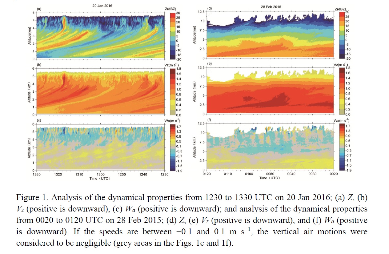
Highlights:
- The 6 snow events were classified into deep and shallow categories and the snow clouds were divided into GC regions and St regions for statistical comparison.
- The Wa and Vz values were retrieved more precisely using bimodal spectra from CVPR-FMCW. The vertical structure and continuous evolution of Wa and Vz in the snow clouds were also exhibited more clearly.
- The characteristics of GC regions, as well as the average reflectivity gradients and dynamical properties inside and outside GCs and FSs were quantified, improving the understanding of the differences between the inside and outside of GCs and FSs during the 2 types of snow events in terms of vertical reflectivity gradients and dynamical properties.
Articles
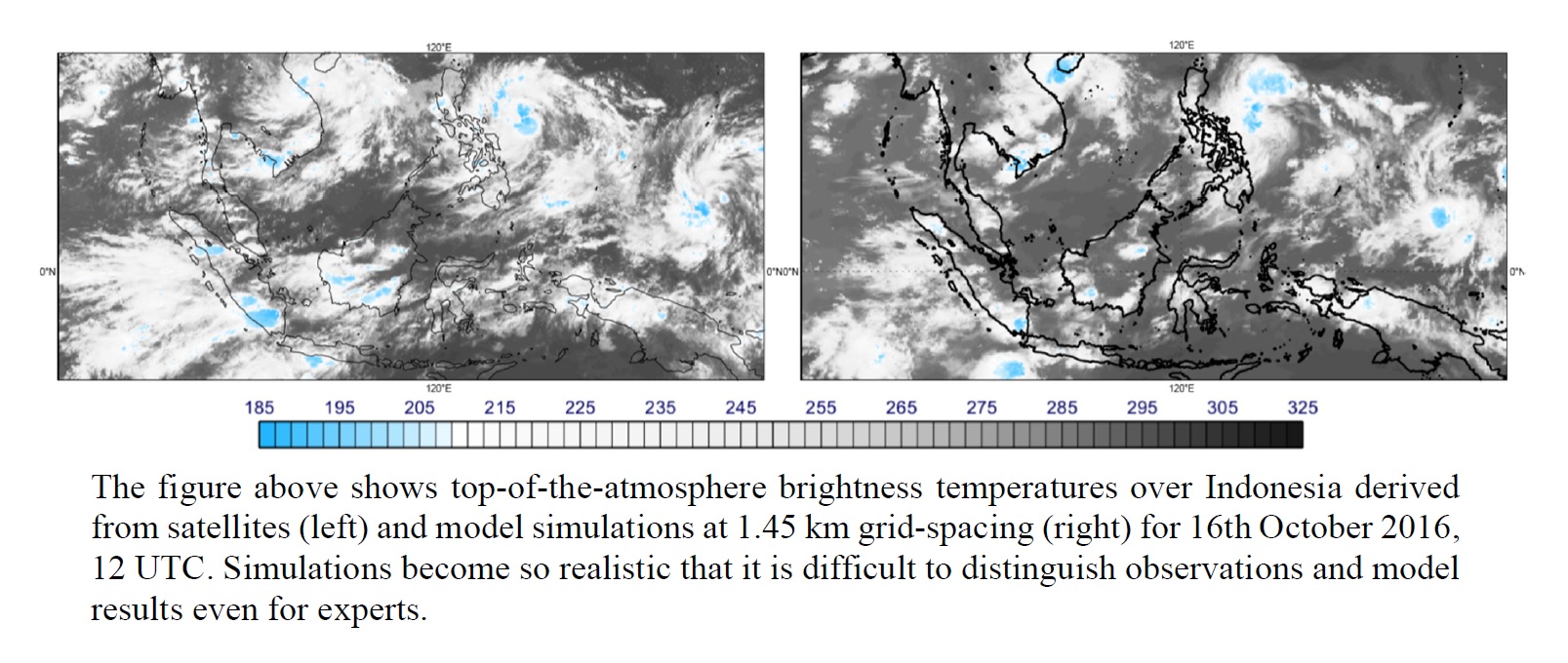
Dueben et al. (2020)
Dueben, P. D., N. Wedi, S. Saarinen, and C. Zeman, 2020: Global simulations of the atmosphere at 1.45 km grid-spacing with the Integrated Forecasting System. J. Meteor. Soc. Japan, 98, 551-572.
Special Edition on DYAMOND: The DYnamics of the Atmospheric general circulation Modeled On Non-hydrostatic Domains,
https://doi.org/10.2151/jmsj.2020-016
Graphical Abstract
Plain Language Summary:
Numerical weather and climate models represent the dynamics of the atmosphere on a numerical grid. As the resolution of this grid is increasing, more and more details can be resolved within the atmosphere model. This comes at a price of increased computational cost paired with additional challenges to run on current and future supercomputers in an energyefficient manner and to manage the resulting data.
This paper presents global simulations of the atmosphere at an unprecedented level of resolution with 1.45 km grid-spacing that allow to represent important features of atmospheric dynamics, such as large thunderstorm systems, explicitly within simulations. The Integrated Forecasting System is used to perform such simulations that show the full complexity for the representation of the atmosphere that would be used in operational weather predictions.
The performance of simulations is diagnosed when running the Integrated Forecasting System on the fastest supercomputer in Europe, called Piz Daint and based at CSCS in Switzerland. Important choices for the model configuration at this unprecedented resolution are discussed and evaluated.
Highlights:
- Simulations with 1.45 km grid-spacing for the atmosphere are possible with the Integrated Forecasting System and scale reasonably well on the largest supercomputer of Europe.
- The numerical formulation of the Integrated Forecasting System – which is based on so-called spectral discretisation methods – is competitive against other models in terms of efficiency at this level of resolution.
- High-resolution simulations show the expected benefit regarding realism and added value for the representation of the atmosphere.
- Further model developments will still be required to optimise forecast skill at this level of resolution.
Articles
Radhakrishna et al. (2020)
Radhakrishna, B., K. Saikranthi, and T. N. Rao, 2020: Regional differences in raindrop size distribution within Indian subcontinent and adjoining seas as inferred from global precipitation measurement dual-frequency precipitation radar. J. Meteor. Soc. Japan, 98, 573-584.
Special Edition on Global Precipitation Measurement (GPM): 5th Anniversary
https://doi.org/10.2151/jmsj.2020-030
Graphical Abstract
Plain Language Summary: Information on raindrop size is useful not only for understanding microphysics of precipitation but also for improving quantitative precipitation estimation, attenuation correction in satellite communications and soil erosion estimates. Understanding the dominant microphysical processes occurring in different climatic regions is also essential for improving the numerical weather prediction (NWP) models. However, measurements of raindrop size are sparse over Indian region, hampering our understanding on the variability of rain drop size in different climatic zones within the South Asian Monsoon. Global Precipitation Mission (GPM) retrieved mass weighted mean diameters (Dm) have been used, for the first time, to understand microphysical variations in different climatic zones of India. Rain rate stratified raindrop size exhibits large spatial variations with larger Dm in dry regions and smaller Dm over oceans. Significant evaporation in dry regions of India and low-level hydrometeor growth over oceans are found to be the dominant microphysical processes controlling the rain drop size. It is also noted that bigger cloud drops not always yield bigger rain drops, particularly over dry continental regions, because of the microphysical processes during the drop descent.
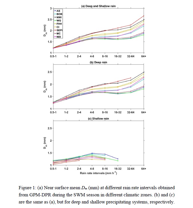
Highlights:
- Regional differences in rain microphysics (DSD) within South Asian monsoon have been investigated for the first time using GPM measurements.
- Dm show significant spatial variations, indicating large differences in raindrop growth/decay processes in different climatic zones.
- The cloud drops are smaller in size over continental dry regions but the raindrops are larger due to the evaporation of smaller drops.
Articles
Geng and Katsumata (2020)
Geng, B., and M. Katsumata, 2020: An algorithm for detecting and removing the spurious differential phase observed by C-band polarimetric radar in the rain. J. Meteor. Soc. Japan, 98, 585-613.
Special Edition on Years of the Maritime Continent (YMC)
https://doi.org/10.2151/jmsj.2020-031
Graphical Abstract
Plain Language Summary: An algorithm is developed to detect the spurious differential phase ФDP and specific differential phase KDP in the rain. The development and validation of the algorithm was conducted using the data observed by the C-band polarimetric radar aboard the research vessel Mirai during a pilot field campaign of the Years of the Maritime Continent (YMC) project. The algorithm developed in this study facilitates the quality control of ФDP and KDP.
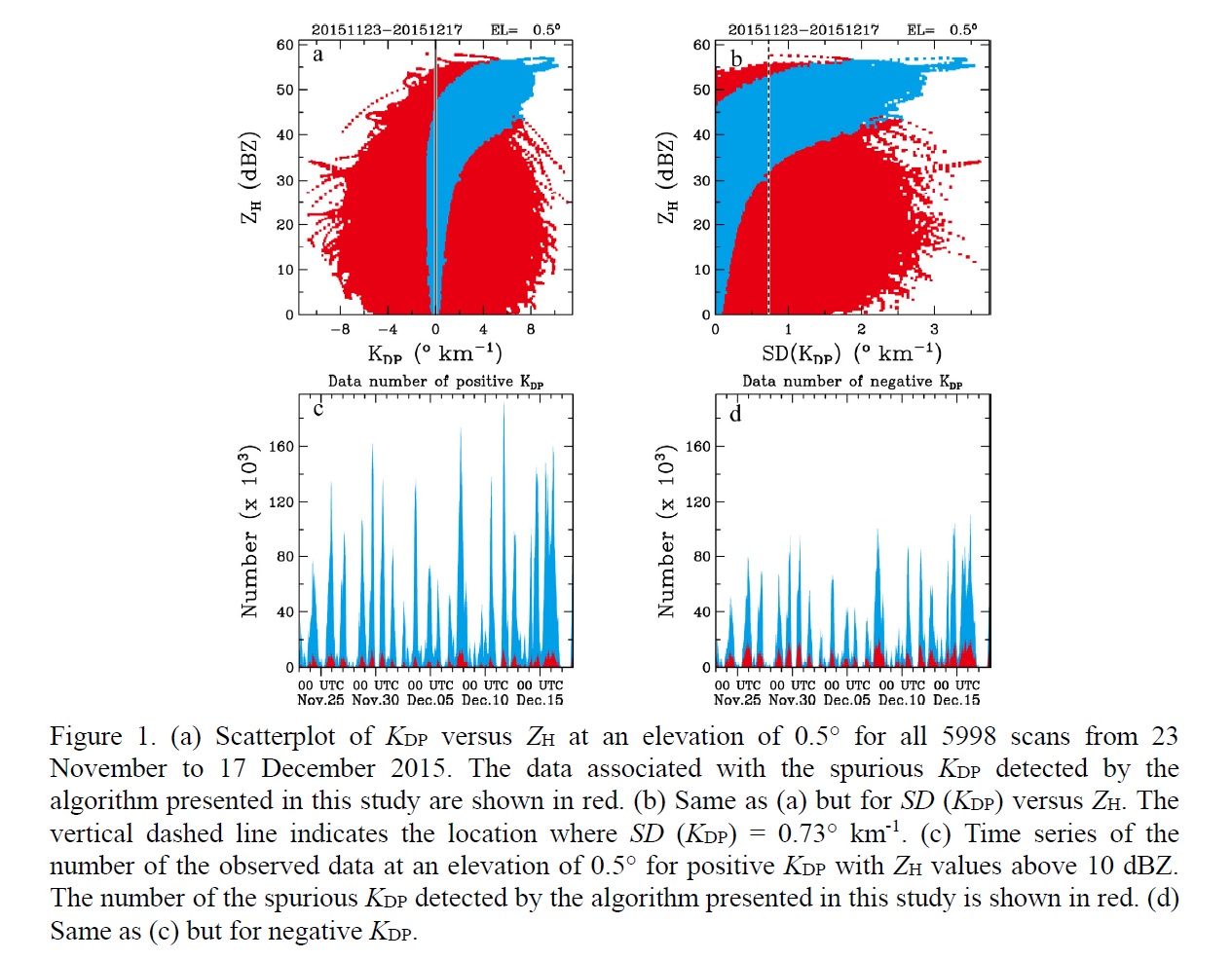
Highlights:
- The algorithm is a threshold filter that is designed based on the empirical relationship between the KDP and radar reflectivity factor at horizontal polarization ZH for raindrops.
- The positively and negatively biased KDP values can be efficiently detected by this new algorithm, while quality data, especially those with high ZH values, remain unaffected as far as possible.
- The standard deviation of the KDP in areas with relatively low ZH is also significantly reduced by applying the algorithm.
Articles
Shibata and Lehmann (2020)
Shibata, K., and R. Lehmann, 2020: Partitioning of ozone loss pathways in the ozone quasi-biennial oscillation simulated by a chemistry-climate model. J. Meteor. Soc. Japan, 98, 615-636.
https://doi.org/10.2151/jmsj.2020-032
Graphical Abstract
Plain Language Summary: Ozone loss pathways due to NOx, HOx, ClOx, Ox, and BrOx catalytic cycles and their rates in the ozone quasi-biennial oscillation (QBO) simulated by a chemistry-climate model of the Meteorological Research Institute of Japan are evaluated by using an objective pathway analysis program (PAP). The QBO amplitude of the sum of all cycles amounts to about 4 and 14 % of the annual mean of the total ozone loss rate at 10 and 20 hPa, respectively. The contribution of catalytic cycles to the QBO of the ozone loss rate is found to be as follows: NOx cycles contribute the largest fraction (50-85 %) of the QBO amplitude of the total ozone loss rate; HOx cycles are the econd-largest (20-30 %) below 30 hPa and the third-largest (about 10 %) above 20 hPa; Ox cycles rank third (5-20 %) below 30 hPa and second (about 20 %) above 20 hPa; ClOx cycles rank fourth (5-10 %); and BrOx cycles are almost negligible.
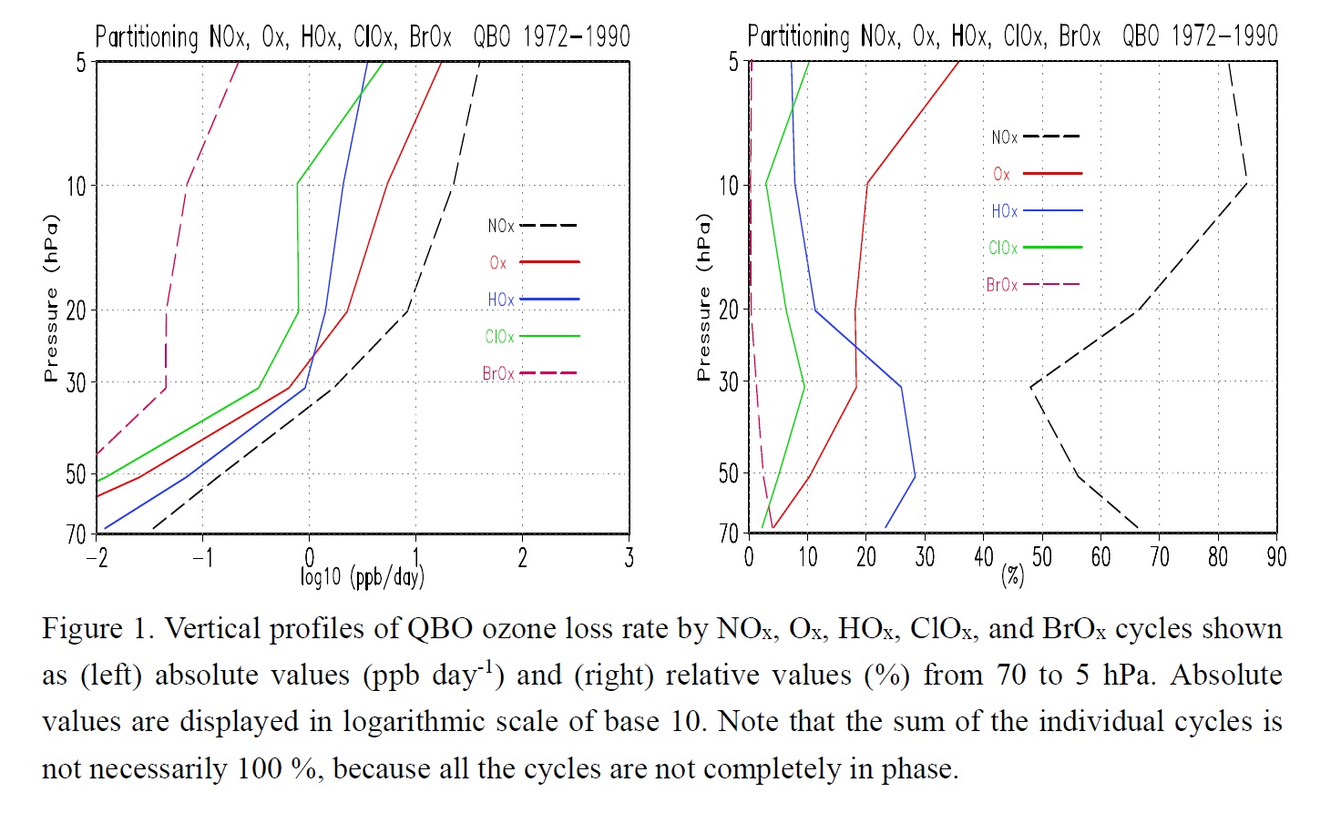
Highlights:
- In the photochemically controlled region at 10 hPa, the NOx cycles contribute about 85 % to the QBO amplitude of the ozone loss rate, in which [NOx] is the major contributor.
- The main contribution to the NOx variation originates in the variation of NOy transport.
- Temperature is the second major contributor through the temperature dependence of [O]/[O3].
- Minor contributions emerge from the QBO variation of the overhead ozone column, which modulates the ozone photolysis, influencing [O]/[O3], and the oxygen photolysis, leading to O3 production.
Articles
Cao et al. (2020)
Cao, X., R. Wu, N. Wei, and Y. Dai, 2020: Location of the preferred region for tropical cyclogenesis in strong monsoon trough pattern over the western North Pacific. J. Meteor. Soc. Japan, 98, 637-654.
https://doi.org/10.2151/jmsj.2020-034
Graphical Abstract
Plain Language Summary: The processes of tropical cyclone (TC) genesis in strong monsoon trough pattern over the western North Pacific (WNP) are examined using reanalysis data and numerical experiments. Composite analysis showed that more TCs are likely to form in the central WNP and that fewer TCs appear in the western and eastern WNP. Numerical experiments with the same weak artificial vortices inserted into eight different regions of the monsoon trough showed that weak tropical disturbances tend to develop more rapidly in the central WNP, whereas weak tropical disturbances tend to develop more slowly in the eastern and western WNP. The failure of TC genesis in the western WNP is due to the decrease of the moisture and heat. And large vertical wind shear and dry conditions hinder the intensification of tropical disturbances in the eastern WNP.
Highlights:
- Composite analysis showed that more TCs are likely to form in the central WNP and that fewer TCs appear in the western and eastern WNP when monsoon trough extends southeastward.
- Modeling results showed that weak tropical disturbances tend to develop more rapidly in the central WNP, whereas weak tropical disturbances tend to develop more slowly in the eastern and western WNP.
- The failure of TC genesis in the western WNP is due to the decrease of the moisture and heat, whereas large vertical wind shear and dry conditions hinder the development of tropical disturbances in the eastern WNP.
Notes and Correspondence
Naoi et al. (2020)
Naoi, M., Y. Kamae, H. Ueda, and W. Mei, 2020: Impacts of seasonal transitions of ENSO on atmospheric river activity over East Asia. J. Meteor. Soc. Japan, 98, 655-668.
https://doi.org/10.2151/jmsj.2020-027
Graphical Abstract
Plain Language Summary: Atmospheric Rivers (ARs), narrow water vapor transport bands over the mid-latitude, often cause natural disaster when they make landfall. Occurrence frequency of ARs is perturbated over East Asia in association with seasonal transitions of the El Niño Southern Oscillation. A rapid transition from preceding-winter El Niño to summertime La Niña results in more AR occurrence through enhancement and northward expansion of the anticyclone over the western North Pacific.
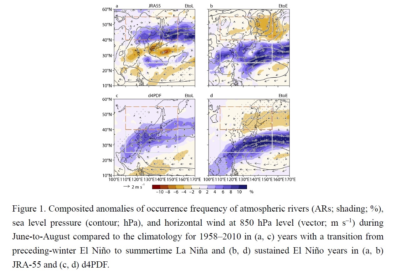
Highlights:
- The relationship between the seasonal transitions of ENSO and the summertime AR activity over East Asia are examined using an atmospheric reanalysis and high-resolution model ensemble simulations.
- A rapid transition from preceding-winter El Niño to summertime La Niña results in more AR occurrence over northern East Asia.
- The anomalies of AR activity and atmospheric circulation are consistent with a steady response of the atmosphere to the anomalous condensation heating over the Maritime Continent and equatorial Pacific associated with the ENSO transition.
JMSJ, 2020, Vol. 98, No. 4 (August)
Articles
Kawano and Kawamura (2020)
Kawano, T., and R. Kawamura, 2020: Genesis and maintenance processes of a quasi-stationary convective band that produced record-breaking precipitation in northern Kyushu, Japan on 5 July 2017. J. Meteor. Soc. Japan, 98, 673-690.
https://doi.org/10.2151/jmsj.2020-033
Graphical Abstract
Plain Language Summary: A quasi-stationary convective band that persisted for approximately ten hours caused precipitation in the northern part of Kyushu Island, Japan on 5 July 2017. The extreme amount of rainfall produced by this convective band caused a number of landslides and flash floods and resulted in a severe disaster. The Weather and Research and Forecasting (WRF) model simulations revealed that a quasi-stationary convergence zone in the low level played a crucial role in generating and maintaining the convective band.
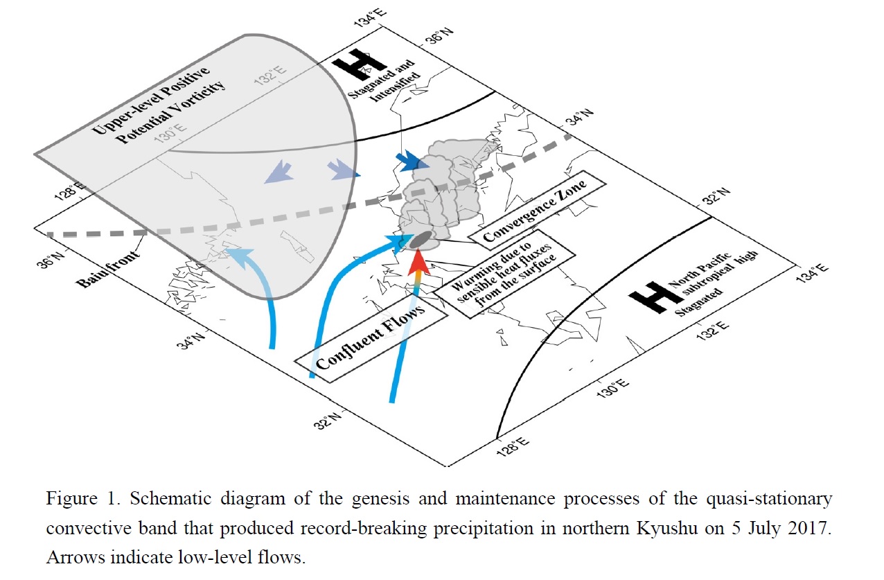
Highlights:
- Low-level confluent flows due to the blocking effects of a high pressure system located over the Sea of Japan were responsible for the formation, intensification, and sustenance of the convergence zone.
- The frontal structure of the convergence zone was intensified due to the land-sea thermal contrast between Kyushu Island and the Tsushima Strait.
- Topography and a cold pool due to raindrop evaporation played only minor roles in the genesis and maintenance of the convective band.
Articles
Takamura and Wada (2020)
Takamura, N., and A. Wada, 2020: Unusual characteristics of extratropical transition of typhoons in August 2016. J. Meteor. Soc. Japan, 98, 691-706.
https://doi.org/10.2151/jmsj.2020-035
Graphical Abstract
Plain Language Summary: To identify the unusual characteristics such as frequent landfall and extratropical transition in August 2016, this study examines typhoons in August and September by conducting k-means cluster, cyclone phase space and composite analyses and case study. We also compare the results of the analyses for this period with those in August from 2001 to 2015 and those in September 2016. As a result, the synoptic environments around the typhoons explain the unusual track and the frequent extratropical transition in August 2016.
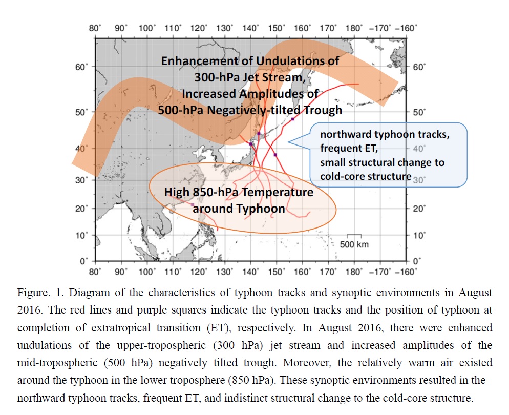
Highlights:
- The direction of the typhoon tracks in August 2016 is northward.
- Extratropical transition in August 2016 is characterized by an indistinct structural change from a warm-core structure to a cold-core structure.
- The synoptic environments around the typhoons in August 2016 are characterized by enhanced undulations of the upper-tropospheric jet stream, increased amplitudes of the mid-tropospheric trough, and relatively warm air around the typhoons in the lower troposphere.
Articles
Wang et al. (2020)
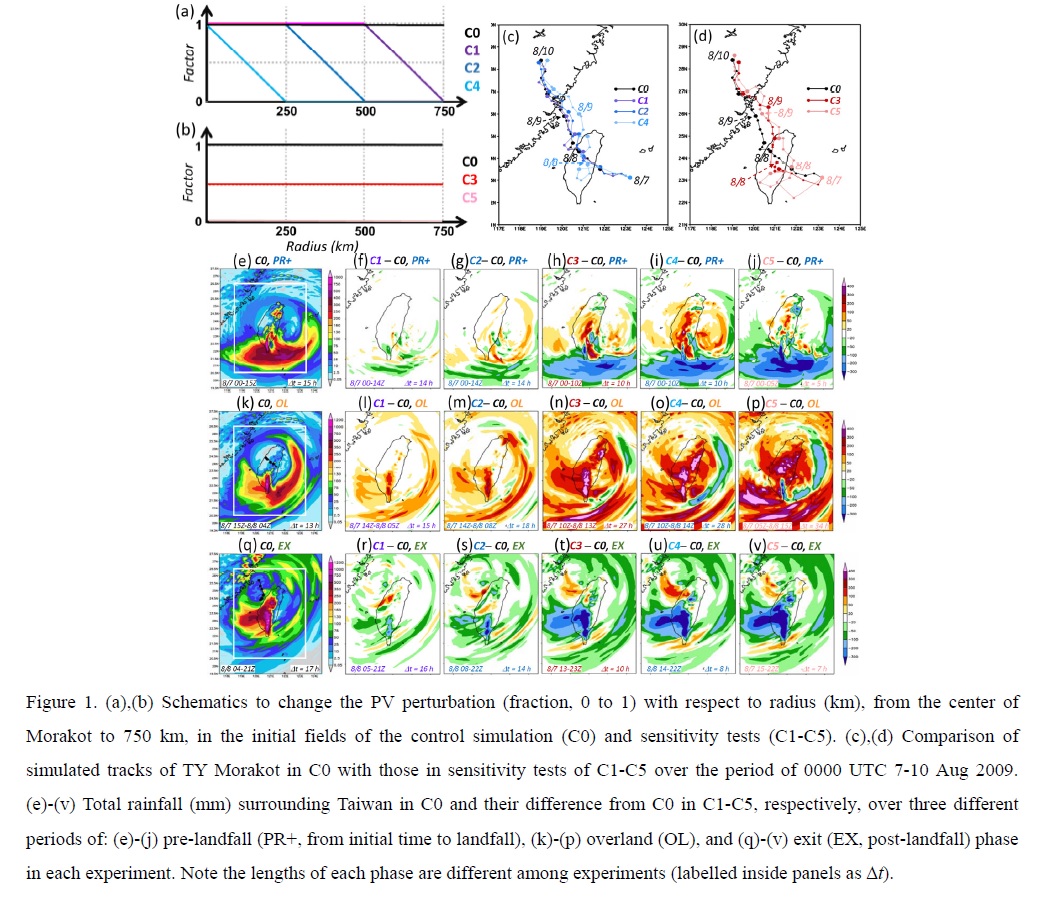
Wang, C.-C., K.-Y. Lin, C. A. Davis, S.-Y. Huang, S. C.-S. Liu, K. Tsuboki, and B. J.-D. Jou, 2020: A modeling study on the impacts of Typhoon Morakot’s (2009) vortex structure on rainfall in Taiwan using piecewise potential vorticity inversion. J. Meteor. Soc. Japan, 98, 707-733.
https://doi.org/10.2151/jmsj.2020-036
Graphical Abstract
Plain Language Summary: In this study, the impacts of Typhoon Morakot’s (2009) vortex structure on the extreme rainfall in Taiwan are investigated through modeling with an application of piecewise potential vorticity (PV) inversion. The control experiment (C0), starting at 0000 UTC 7 August or 15 h before landfall, reproduces the event realistically and is validated against the observations. By altering the PV perturbation inside 750 km from its center, we conduct sensitivity experiments in which the size and/or circulation strength of Morakot is reduced/weakened in the initial field in several different ways.
Highlights:
- Taiwan receives an overall rainfall amount either comparable to, or even more than (up to +12%), C0 in all tests. This result shows the strong southwesterly flow and its moisture supply were bigger factors than the vortex structure.
- In the southern Central Mountain Range on 8 August, the rainfall tended to decrease by up to 40% with the contraction and a weaker outer circulation, indicating that the vortex structure plays an important role in the rainfall of this region.
Articles
Feng et al. (2020)
Feng, T., X.-Q. Yang, L. Wu, R. Huang, and D. Yang, 2020: How do the monsoon trough and the tropical upper-tropospheric trough affect synoptic-scale waves: A comparative study. J. Meteor. Soc. Japan, 98, 735-754.
https://doi.org/10.2151/jmsj.2020-037
Graphical Abstract
Plain Language Summary: As an important precursor for tropical cyclone formation, a conventional synoptic-scale disturbance is usually identified from lower-tropospheric winds over the western North Pacific. However, another type of disturbance with the maximum perturbation in the upper troposphere may be misidentified. Comparing two long-lasting synoptic-scale wave events in 2004 and 2006, the present study showed that the disturbances occurred in the upper troposphere in 2006 while in the lower troposphere in 2004. Such a difference is ascribed to the large-scale background modulated by both the monsoon trough and the tropical upper-tropospheric trough.
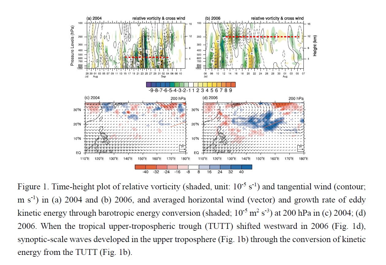
Highlights:
- Distinct three-dimensional structures in synoptic-scale disturbances during 2004 and 2006 were investigated.
- Differences in the vertical structure indicated the diverse properties of these disturbances.
- The displacements of the monsoon trough, the tropical upper-tropospheric trough (TUTT), and associated vertical wind shear caused the structural change in these disturbances.
Articles
Yamaji et al. (2020)
Yamaji, M., H. G. Takahashi, T. Kubota, R. Oki, A. Hamada, and Y. N. Takayabu, 2020: 4-year climatology of global drop size distribution and its seasonal variability observed by spaceborne Dual-frequency Precipitation Radar. J. Meteor. Soc. Japan, 98, 755-773.
Special Edition on Global Precipitation Measurement (GPM): 5th Anniversary
https://doi.org/10.2151/jmsj.2020-038
Graphical Abstract
Plain Language Summary: Global-scale spatial distributions of rainfall drop size (mean diameter; Dm) are newly obtained by using 4-year accumulated products from the spaceborne precipitation radar. Relationship between Dm and precipitation rate is not a simple one-to-one relationship. Focusing on the seasonal variation in Dm over the northwest Pacific Ocean, the results indicate that the variation in Dm is related to the seasonal change of the dominant precipitation systems.
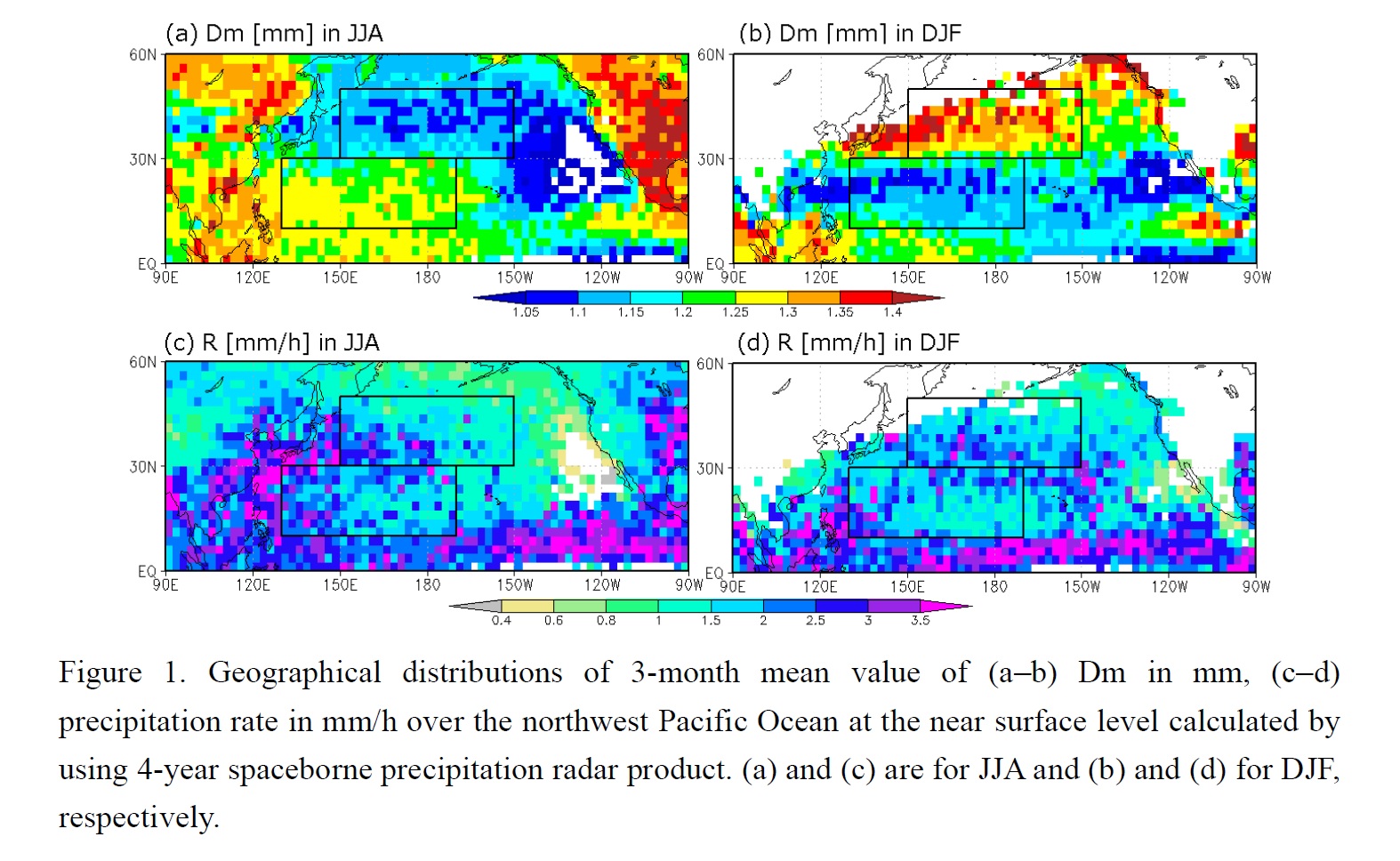
Highlights:
- Over the northern Pacific Ocean, Dm is larger in winter and smaller in summer over the mid-latitude regions and an opposite seasonal variation is seen over subtropical regions; the signals are statistically significant.
- For both subtropical and mid-latitude regions in JJA, precipitation top heights are high and both stratiform and convective precipitation exist, indicating characteristics of organized precipitation systems.
- For DJF over mid latitudes, the stratiform ratio is high but precipitation top heights are not as high as those in JJA, corresponding to the features of extratropical frontal systems.
- For DJF over the subtropics, a feature that precipitation top heights are lowest and convective precipitation is dominant is confirmed, indicating the shallow convective precipitation systems with trade wind cumulus or cumulus congestus.
Articles
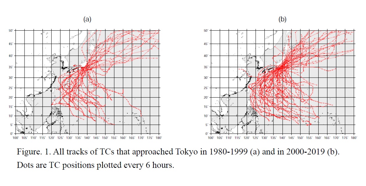
Yamaguchi and Maeda (2020)
Yamaguchi, M., and S. Maeda, 2020: Increase in the number of tropical cyclones approaching Tokyo
since 1980. J. Meteor. Soc. Japan, 98, 775-786.
https://doi.org/10.2151/jmsj.2020-039
Graphical Abstract
Plain Language Summary: This study investigated whether tropical cyclones (TCs) approaching Tokyo have changed in terms of number and environmental conditions using observational and reanalysis data during the geostationary satellite era (1980-2019). The number of TCs approaching the southern coast of Japan, including Tokyo, has increased over the last 40 years. The environmental conditions for TC development have become more favorable, with warmer sea surface temperature, less vertical wind shear, and more moisture in the atmosphere. In addition, the translation speed of TCs has decreased, which indicates a longer influence time.
Highlights:
- Comparison of the synoptic environment during July–October between the first (1980–1999, P1) and second (2000–2019, P2) 20 years shows that the sub-tropical high is strengthened in P2.
- Also, the westerly jet is weakened in P2 over and south of Japan in the middle-to-upper troposphere.
- Decadal oscillations may have played some role in the increase in the number of approaching TCs and in the changes in the synoptic environment.
Articles
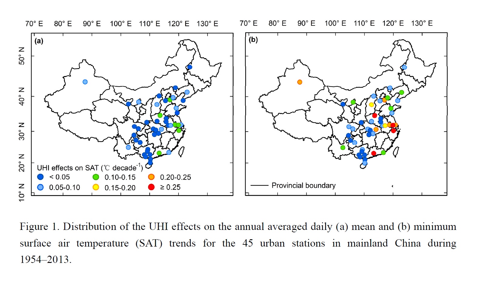
Jin et al. (2020)
Jin, K., F. Wang, Q. Zong, P. Qin, and C. Liu, 2020: An updated estimate of the urban heat island effect on observed local warming trends in mainland China's 45 urban stations. J. Meteor. Soc. Japan, 98, 787-799.
https://doi.org/10.2151/jmsj.2020-040
Graphical Abstract
Plain Language Summary: Surface air temperature (SAT) in many Chinese cities has experienced dramatic increase due to rapid urbanization and global warming. This study built several linear regression equations by linking SAT trend with a modified urban impact indicator. Severe UHI effects on annual mean and minimum SATs of the 45 urban stations in mainland China during 1954–2013 are found.
Highlights:
- A modified urban impact indicator (MUii ) representing the extent to which the observed temperature from a given station was influenced by UHI effects is proposed.
- Several linear regressions between difference in the SAT trend between the urban and adjacent stations and difference in the MUii change between the urban and adjacent stations for the 45 station pairs are built.
- The annual averaged daily mean and minimum SAT trends of the 45 urban stations in mainland China during 1954–2013 are approximately 0.05 and 0.11 °C decade−1, respectively, accounting for 18% and 31% of the overall warming trends, respectively.
Articles
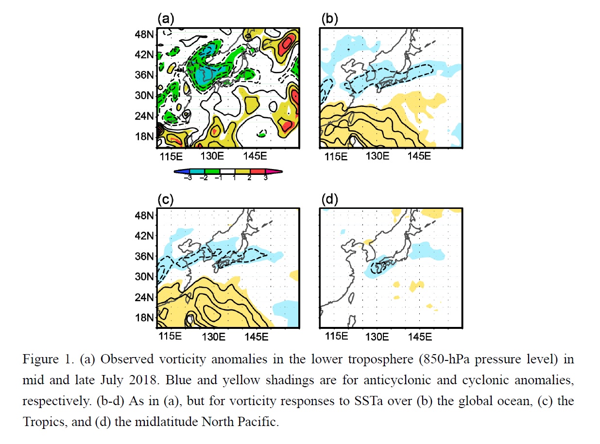
Nishii et al. (2020)
Nishii, K., B. Taguchi, and H. Nakamura, 2020: An atmospheric general circulation model
assessment of oceanic impacts on extreme climate events over Japan in July 2018. J. Meteor. Soc. Japan, 98, 801-820.
Special Edition on Extreme Rainfall Events in 2017 and 2018
https://doi.org/10.2151/jmsj.2020-041
Graphical Abstract
Plain Language Summary: Oceanic impacts on anomalous atmospheric circulation that caused the heavy rain event and heat wave observed in July 2018 over Japan are investigated. While a pair of anticyclonic and cyclonic anomalies during the heavy rain was unlikely forced by the sea surface temperature anomaly (SSTa), a warm anticyclonic anomaly over Japan during the heat wave was partly forced by the SSTa in the midlatitude North Pacific Ocean as well as in the Tropics.
Highlights:
- Impacts of midlatitude and tropical oceans on the circulation anomalies that induced the two extreme events are assessed separately with an atmospheric general circulation model (AGCM).
- The circulation anomaly that induced the heavy rain cannot be reproduced in the model, suggesting that the anomaly was unlikely forced by SSTa but likely due to internal variability.
- The circulation anomaly that induced the heat wave is reproduced in the model, which suggests an active role of both the tropical and midlatitude SSTa in forcing the circulation anomaly.
Articles
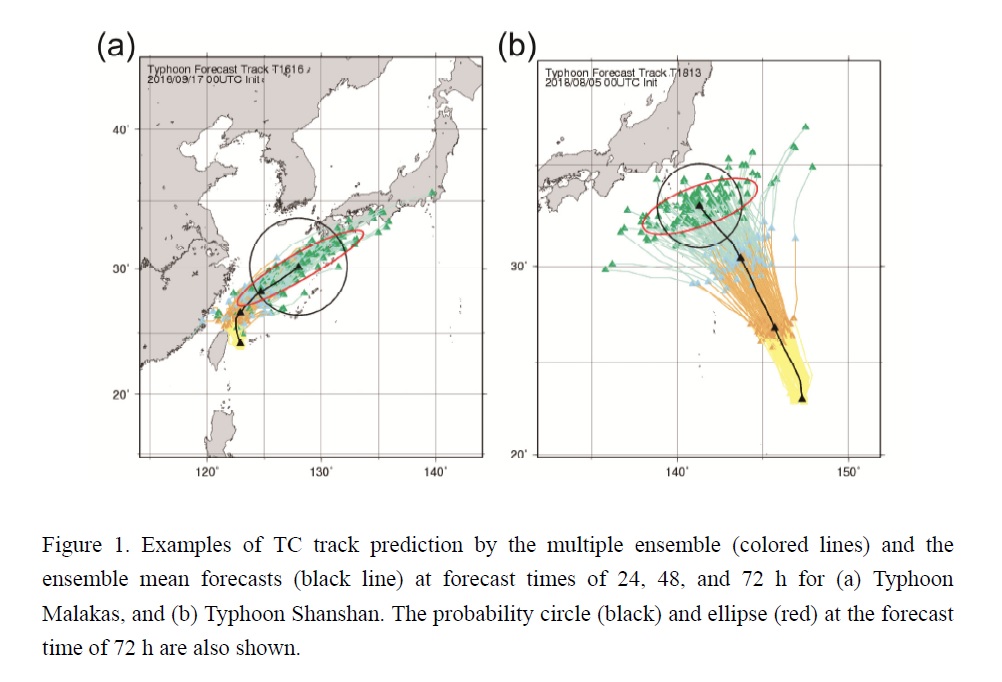
Kawabata and Yamaguchi (2020)
Kawabata, Y., and M. Yamaguchi, 2020: Probability ellipse for tropical cyclone track forecasts with multiple ensembles. J. Meteor. Soc. Japan, 98, 821-833.
https://doi.org/10.2151/jmsj.2020-042
Graphical Abstract
Plain Language Summary: The effectiveness of the probability ellipse for tropical cyclone (TC) track forecasts is investigated with multiple ensembles from the Japan Meteorological Agency (JMA), the European Centre for Medium-Range Weather Forecasts (ECMWF), the U.S. National Centers for Environmental Prediction (NCEP), and the Met Office in the United Kingdom (UKMO), for all TCs from 2016 to 2018. The multiple ensembles composed of these four global ensembles are capable of predicting the situation-dependent uncertainties of TC track forecasts appropriately in both the along-track and cross-track directions.
Highlights:
- The introduction of the probability ellipse makes it possible to provide information as to which is more uncertain; the direction or the speed of TC movement.
- Compared to the probability circle adopted operationally at JMA, the probability ellipse can potentially reduce the area by 16, 15, 24 %, on average, at forecast times of 3, 4, and 5 days, respectively.
- Narrowing warning areas of TC track forecasts by the probability ellipse enables us to enhance disaster prevention/mitigation measures.
Articles
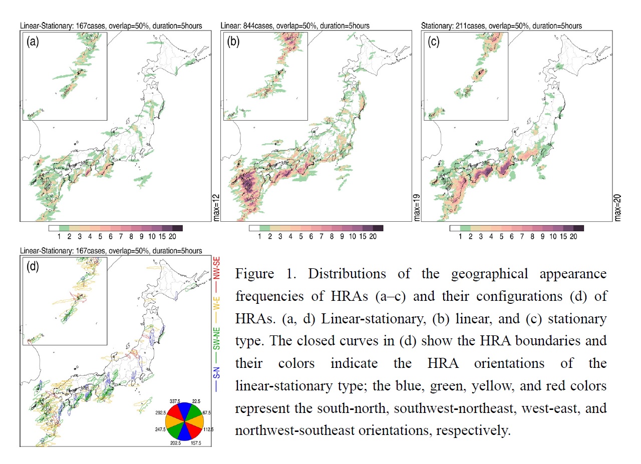
Hirockawa et al. (2020)
Hirockawa, Y., T. Kato, H. Tsuguti, and N. Seino, 2020: Identification and classification of heavy rainfall areas and their characteristic features in Japan. J. Meteor. Soc. Japan, 98, 835-857.
Special Edition on Extreme Rainfall Events in 2017 and 2018
https://doi.org/10.2151/jmsj.2020-043
Graphical Abstract
Plain Language Summary: We propose a new procedure for the objective identification and classification of heavy rainfall areas (HRAs) to advance the understanding of mesoscale convective systems (MCSs) in Japan. The distributions of accumulated precipitation amounts are evaluated from the radar/raingauge-analyzed precipitation amounts and characteristic features of HRAs are examined. The HRAs extracted during the warm season (April–November) in 2009–2018 are classified into four types (e.g., linear-stationary, linear, stationary, and others) from their morphological features and temporal variations.
Highlights:
- HRAs are frequently distributed on the Pacific sides of eastern and western Japan; 80% of HRAs appeared from June to September and 60% of the HRAs were observed in association with stationary fronts and tropical cyclones.
- Most HRAs are reasonably identified and classified based on their morphological features despite the simplified procedures, e.g., approximately 80% of those HRAs of the linear-stationary type corresponded to typical elongated and stagnated MCSs, as has been suggested in previous studies.
Articles
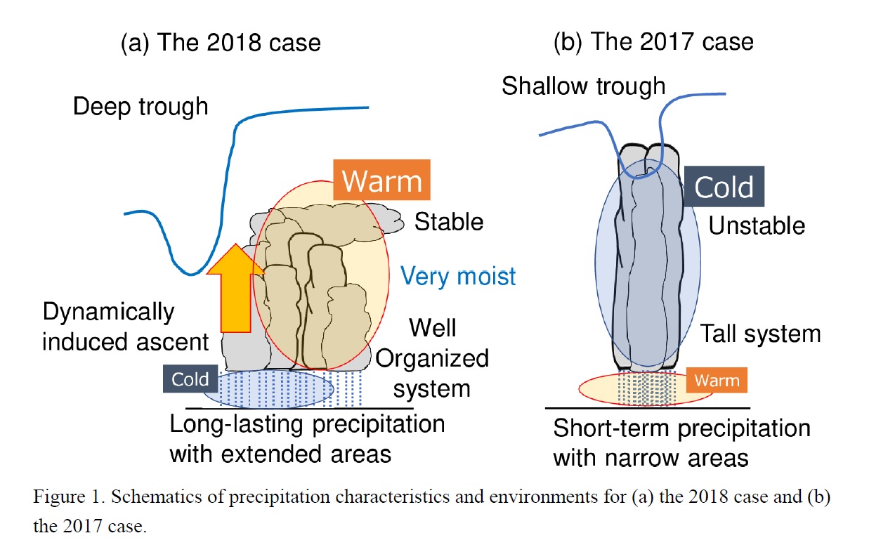
Tsuji et al. (2020)
Tsuji, H., C. Yokoyama, and Y. N. Takayabu, 2020: Contrasting features of the July 2018 heavy rainfall event and the 2017 Northern Kyushu rainfall event in Japan. J. Meteor. Soc. Japan, 98, 859-876.
Special Edition on Extreme Rainfall Events in 2017 and 2018
https://doi.org/10.2151/jmsj.2020-045
Graphical Abstract
Plain Language Summary: Precipitation characteristics and environment are compared between two rainfall events in Japan: the July 2018 heavy rainfall event (2018 case) and the 2017 Northern Kyushu rainfall event (2017 case). The 2018 case was characterized by long-lasting heavy precipitation over a wide area, well-organized moderately tall precipitation systems, stable and very moist environment compared with the climatology, and large quasi-geostrophic forcing associated with an upper tropospheric trough. In contrast, the 2017 case was characterized by short-term extreme precipitation over a narrow area, exceptionally tall precipitation systems, unstable and moist environment compared with the climatology, and weak quasi-geostrophic forcing. These contrasts are similar to those found between composites of extremely heavy rainfall events and extremely tall convection events in the previous statistical study by Hamada and Takayabu (2018, doi:10.1175/JCLI-D-17-0632.1).
Highlights:
- Contrasting precipitation properties and environments are observed between two rainfall events in Japan: the July 2018 heavy rainfall event and the 2017 Northern Kyushu rainfall event.
- The contrast is similar to that found between composites of extreme rainfall events and extremely tall convection events included in the previous statistical study by Hamada and Takayabu (2018).
JMSJ, 2020, Vol. 98, No. 5 (October)
Review Articles
Mesinger and Veljovic (2020)
Mesinger, F., and K. Veljovic, 2020: Topography in weather and climate models: Lessons from cut-cell Eta vs. European Centre for Medium-Range Weather Forecasts experiments. J. Meteor. Soc. Japan, 98, 881-900.
https://doi.org/10.2151/jmsj.2020-050
Graphical Abstract
Plain Language Summary: Advantages and issues of methods of incorporating topography in weather and climate models are summarized. Terrain-following coordinates used in almost all major models do have issues with steepness of model terrain exceeding a given limit. Immersed boundary methods accept both the grid and the model topography as they are and address prescription of boundary conditions and adjustments of physics parameterizations. Cut-cell schemes prescribe bottoms of their lowest cells to define topography and are able to use finite-volume discretizations. New views are offered via analyses of experiments driving cut-cell Eta by European Centre for Medium-Range Weather Forecasts (EC) 32-day ensemble members.
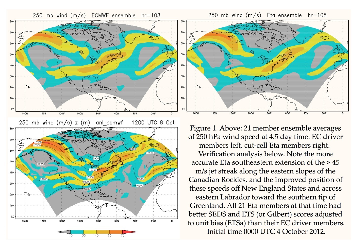
Highlights:
- Using about the same resolution during the first 10 days of the experiment, at the time of a large scale trough crossing the Rockies topographic barrier, cut-cell Eta members achieved overall substantially better verification scores with respect to 250 hPa wind speed than their EC driver members according to each of three verification scores used;
- A single model experiment of running the same ensemble except for the Eta switched to use the terrain-following sigma coordinate, showed that the terrain-intersecting eta was responsible for a considerable part, but not all, of this Eta added skill;
- Identifying features of the Eta using sigma which could be primarily contributing to this increased skill thus appears as an issue deserving attention.
Articles
Song et al. (2020)
Song, H.-J., S. Kim, S. Roh, and H. Lee, 2020: Difference between Cloud Top Height and Storm Height for heavy rainfall using TRMM measurements. J. Meteor. Soc. Japan, 98, 901-914.
Special Edition on Global Precipitation Measurement (GPM): 5th Anniversary
https://doi.org/10.2151/jmsj.2020-044
Graphical Abstract
Plain Language Summary: This study investigates the cloud top height (CTH) and storm height (SH) characteristics of heavy rain clouds from Tropical Rainfall Measuring Mission (TRMM) measurements. Continental heavy rainfall (e.g., Central Africa and the United States) is characterized by high SH under the strong instability and relatively dry conditions. In contrast, heavy rain events in Korea and Japan are mostly related with the lowest CTH, SH, and ice water content under the thermodynamically near-neutral but humid environments, representing unique monsoon feature in the world. Similar SH and humid features are also found in the northwestern Pacific; however, this region exhibits high CTH and CTH−SH values in the highest convective instability condition.
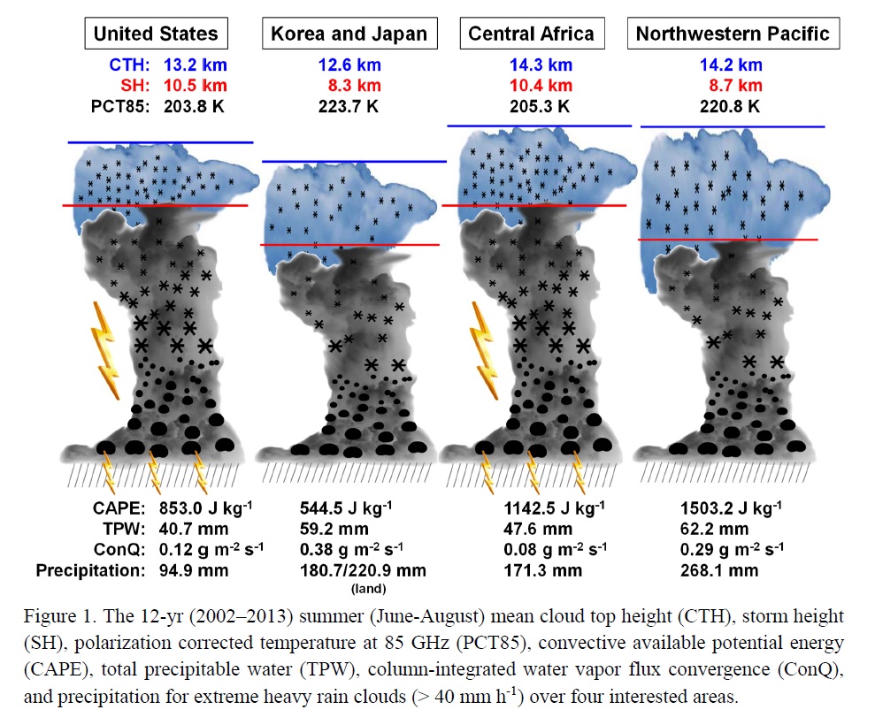
Highlights:
- CTH of heavy rainfall is estimated using VIRS brightness temperature and reanalysis data.
- Continental (oceanic) rainfall regimes are characterized by relatively high (low) SH.
- Heavy rain events with lower CTH/SH in Korea/Japan appear to be very unique in the world.
Articles
Nakamura et al. (2020)
Nakamura, Y., T. Miyakawa, and M. Satoh, 2020: The role of Typhoon Kilo (T1517) in the
Kanto-Tohoku heavy rainfall event in Japan in September 2015. J. Meteor. Soc. Japan, 98, 915-926.
https://doi.org/10.2151/jmsj.2020-046
Graphical Abstract
Plain Language Summary: The Kanto-Tohoku heavy rainfall event in September 2015 is characterized by two typhoons, Etau (T1518) and Kilo (T1517). This study investigates the role of typhoon Kilo on the heavy rainfall. We carried out 3 numerical experiments: the control experiment (CTL), the early initialized experiment (EARLY) and the moisture-removed experiment (RH0). We found that southeasterly wind effectively supplied moisture to the Kanto region. The high-pressure ridge is an important factor for northwestward moisture supply, and stronger simulated Kilo disturbs the ridge, resulting in decreased precipitation.
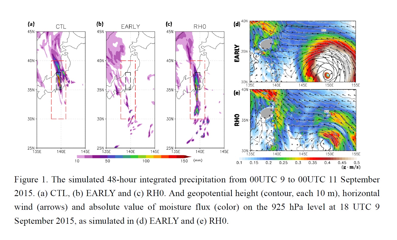
Highlights:
- The early initialized experiment (EARLY) did not simulate sufficient amount of rainfall despite strongly simulated Kilo. On the other hand, the moisture-removed experiment (RH0) simulated heavy rainfall. Precipitation in RH0 is as active as in the control experiment, although typhoon Kilo is weaker simulated.
- In this event, moist air was brought to the Kanto region via a high-pressure ridge, by southeasterly wind. Stronger simulated Kilo disturbs the ridge, resulting in decreased precipitation.
- This high-pressure ridge is sensitive to the profile of Kilo, such as track and intensity. Accurate forecasting of typhoon track and intensity is important for the prediction of relatively remote heavy rainfall events.
Articles
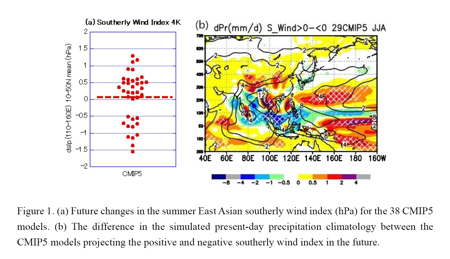
Ose et al. (2020)
Ose, T., Y. Takaya, S. Maeda, and T. Nakaegawa, 2020: Resolution of summertime East Asian pressure pattern and southerly monsoon wind in CMIP5 multi-model future projections. J. Meteor. Soc. Japan, 98, 927-944.
https://doi.org/10.2151/jmsj.2020-047
Graphical Abstract
Plain Language Summary: The southerly surface wind index over the summertime East Asia (SWI) is strengthened in the future in the fifth phase of the Coupled Model Intercomparison Project (CMIP5). However, the differences among the models are much larger than the ensemble average (Fig. 1a). The empirical orthogonal function (EOF) analysis is applied to the future changes in the East Asian surface pressure pattern responsible for the SWI. The ensemble average and five EOF modes for the pressure patterns and the associated precipitation changes are identified, and their possible sources are examined. The first mode is high surface pressure anomalies over low Asia Pacific sea surface temperature. The second mode is related to warm temperature anomalies over the Northern Hemisphere continents. The third mode is characterized with suppressed vertical motions over the northern Indian and Pacific oceans. The fourth mode is the Okhotsk High. The fifth mode represents the east–west contrast of the southern East Asian surface pressure anomalies.
Highlights:
- We found the SWI in the future is determined by the mode balance between the land-ocean surface temperature contrast and the suppressed vertical monsoon circulations over the northern Indian and Pacific oceans. The latter is responsible for the large uncertainty in the future SWI.
- The mode-related suppressed vertical motions in global warming reflect the present-day vertical motion (i.e., precipitation) climatology; The future increase/decrease in the SWI tends to be projected by models simulating the relatively small/large Asia Pacific monsoon precipitation over the tropical oceans in the present-day model climatology (Fig. 1b).
Articles
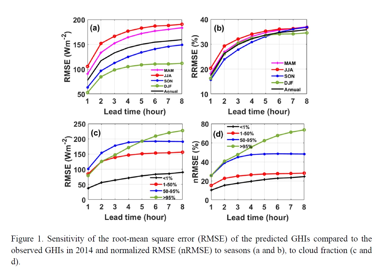
Chen et al. (2020)
Chen, X., X. Huang, Y. Cai, H. Shen, and J. Lu, 2020: Intra-day forecast of ground horizontal irradiance using long short-term memory network (LSTM). J. Meteor. Soc. Japan, 98, 945-957.
https://doi.org/10.2151/jmsj.2020-048
Graphical Abstract
Plain Language Summary: Accurate forecast of ground horizontal irradiance (GHI) is one of the key issues for power grid managements with large penetration of solar energy. A challenge for solar forecasting is to forecast the solar irradiance with a lead time of 1-8 hours, termed as intra-day forecast. This study investigated a machine-learning algorithm, Long Short-Term Memory (LSTM) model, to predict the GHI in 1-8 hours. The results show that, for a 1-4 hour lead time, the LSTM model can predict GHIs better than random-forest forecast (another machine-learning algorithm), and numerical weather forecast by the Weather Research and Forecasting (WRF) model. The LSTM model performs better in fall and winter than in spring and summer, and better under clear-sky conditions than under cloudy conditions. Using adjacent information from the reanalysis as extra inputs can further improve the forecast performance.
Highlights:
- Implementing a machine-learning based intra-day solar irradiance forecast model.
- For a lead time up to four hours, the predicted GHIs have normalized RMSEs at 18.4~33.0%, better than the performance of numerical weather prediction.
- Optimal configurations of the machine-learning model are explored.
Articles
Chen et al. (2020)
Thundathil, R., T. Schwitalla, A. Behrendt, S. K. Muppa, S. Adam, and V. Wulfmeyer, 2020:
Assimilation of lidar water vapour mixing ratio and temperature profiles into a convection-permitting
model. J. Meteor. Soc. Japan, 98, 959-986.
https://doi.org/10.2151/jmsj.2020-049
Graphical Abstract
Plain Language Summary: Ground-based lidar instruments measure profiles of atmospheric moisture and temperature with very high quality and resolution. We show that these data improve the forecasts of the Weather Research and Forecasting (WRF) model. Our model has a grid resolution of 2.5 km, which permits to resolve deep convection. In order to use the new data, we developed a forward operator for the direct assimilation of water vapour mixing ratio (WVMR), a primary variable in the prognostic equations of the WRF model.
Highlights:
- Assimilation of temperature and moisture lidar profiles improved the model significantly.
- A new forward operator for WVMR assimilation avoids relative humidity conversion and thus allows maximum use of the observations eliminating undesirable cross sensitivity to temperature.
- The impact of a single lidar profile spreads over an area with a radius of 150 km showing the potential of a network of lidars for better operational weather forecasts.
Articles
Miyamoto et al. (2020)
Miyamoto, Y., Y. Sato, S. Nishizawa, H. Yashiro, T. Seiki, and A. T. Noda, 2020: An energy balance model for low-level clouds based on a simulation resolving mesoscale motions. J. Meteor. Soc. Japan, 98, 987-1004.
https://doi.org/10.2151/jmsj.2020-051
Graphical Abstract
Plain Language Summary: A new energy balance model is proposed to determine the cloud fraction of low-level clouds by assuming that the horizontal cloud field consists of several individual cloud cells having a similar structure. Using a high-resolution simulation dataset with a wide numerical domain, an energy budget analysis revealed that the energy injected into the domain by surface flux is approximately balanced with the energy loss due to radiation and advection due to large-scale motion. A simple model for the cloud fraction is developed from the energy conservation equation. The cloud fraction diagnosed using the model developed in this study was able to quantitatively capture the simulated cloud fraction.
Highlights:
- An energy balanced model is developed for low-level clouds by assuming that the cloud field consists of finite number of cloud cells with same structure.
- The cloud fraction diagnosed by the developed analytical model is close to that by a high-resolution simulation dataset with a wide numerical domain.
Articles
Cao et al. (2020)
Cao, X., R. Wu, Y. Dai, and J. Xu, 2020: A comparison of the effects of an upper-level anticyclone and a lower-level cyclone on tropical cyclogenesis in idealized simulations. J. Meteor. Soc. Japan, 98, 1005-1027.
https://doi.org/10.2151/jmsj.2020-052
Graphical Abstract
Plain Language Summary: The effects of an upper-level anticyclonic circulation and a lower-level cyclonic circulation on tropical cyclone (TC) genesis are examined by idealized simulations. The simulation results show that the upper-level anticyclonic circulation makes a negative contribution to TC genesis, whereas the lower-level cyclonic circulation makes a positive contribution. The upper-level anticyclonic circulation results in slower TC genesis due to a large vertical zonal wind shear that shifts the upper-level vortex eastward from its initial position, which is unfavorable for the vertical alignment and warm core maintenance of the vortex. The initial upper-level anticyclonic circulation is not necessary for TC genesis, and the strong upper-level anticyclonic circulation generally observed with a strong TC should be regarded as a result of deep convection. In contrast, strong lower-level winds due to the superposition of the large-scale lower-level cyclonic circulation and vortex induce large surface heat fluxes and vorticity, leading to strengthened convection and diabatic heating and a quick build-up of positive vorticity, resulting in rapid TC genesis.
Highlights:
- The upper-level anticyclonic circulation makes a negative contribution to TC genesis, whereas the lower-level cyclonic circulation makes a positive contribution.
- The upper-level anticyclonic circulation results in slower TC genesis due to a large vertical zonal wind shear.
- Strong lower-level winds due to the superposition of the large-scale lower-level cyclonic circulation and vortex induce large surface heat fluxes and vorticity, resulting in rapid TC genesis.
Articles
Hermoso et al. (2020)
Hermoso, A., V. Homar, S. J. Greybush, and D. J. Stensrud, 2020: Tailored ensemble prediction systems: Application of seamless scale bred vectors. J. Meteor. Soc. Japan, 98, 1029-1050.
https://doi.org/10.2151/jmsj.2020-053
Graphical Abstract
Plain Language Summary: Uncertainties in numerical weather forecasting derived from an imperfect knowledge of the initial conditions are coped with ensemble forecasting. Breeding technique provides a simple and low computationally expensive ensemble generation strategy. The technique aims at capturing growing errors, obtained from the difference between control and perturbed runs at regular time intervals. Modifications to the traditional arithmetic rescaling are investigated, including logarithmic and orthogonal rescaling. In addition, the Bred Vectors Tailored Ensemble Perturbations method is designed to control the spatial scale of the perturbations. This technique outperforms traditional breeding techniques in terms of diversity (ensemble dimension) and skill.
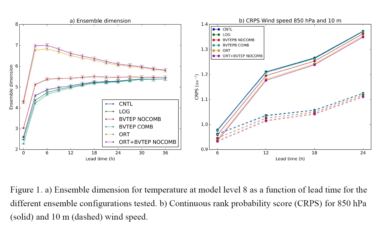
Highlights:
- The use of a different rescaling norm (e.g. logarithmic) in the breeding cycle does not have a significant impact on ensemble performance.
- Ensemble diversity and skill is higher for ensembles with initial perturbations constructed from one bred vector with modified scale.
- The combination of scale modification of perturbations with orthogonalization renders the best diversity and verification results.
Articles
Wang et al. (2020)
Wang, K., G. Chen, X. Bi, D. Shi, and K. Chen, 2020: Comparison of convective and
stratiform precipitation properties in developing and nondeveloping tropical disturbances observed by the Global Precipitation Measurement over the western North Pacific. J. Meteor. Soc. Japan, 98, 1051-1067.
Special Edition on Global Precipitation Measurement (GPM): 5th Anniversary
https://doi.org/10.2151/jmsj.2020-056
Graphical Abstract
Plain Language Summary: A disturbance that develops into a tropical cyclone (TC) over the western North Pacific (WNP) needs to satisfy two essential preconditions in terms of precipitation characteristics from Global Precipitation Measurement (GPM). First, a large fraction of stratiform precipitation covers the region that is within 400 km from the disturbance center. Second, strong convective precipitation occurs within the inner-core (within 200 km of the disturbance center) region. In the TC formation process, the disturbances experience a remarkably more oscillatory process in the inner-core region than in the outer-core region.
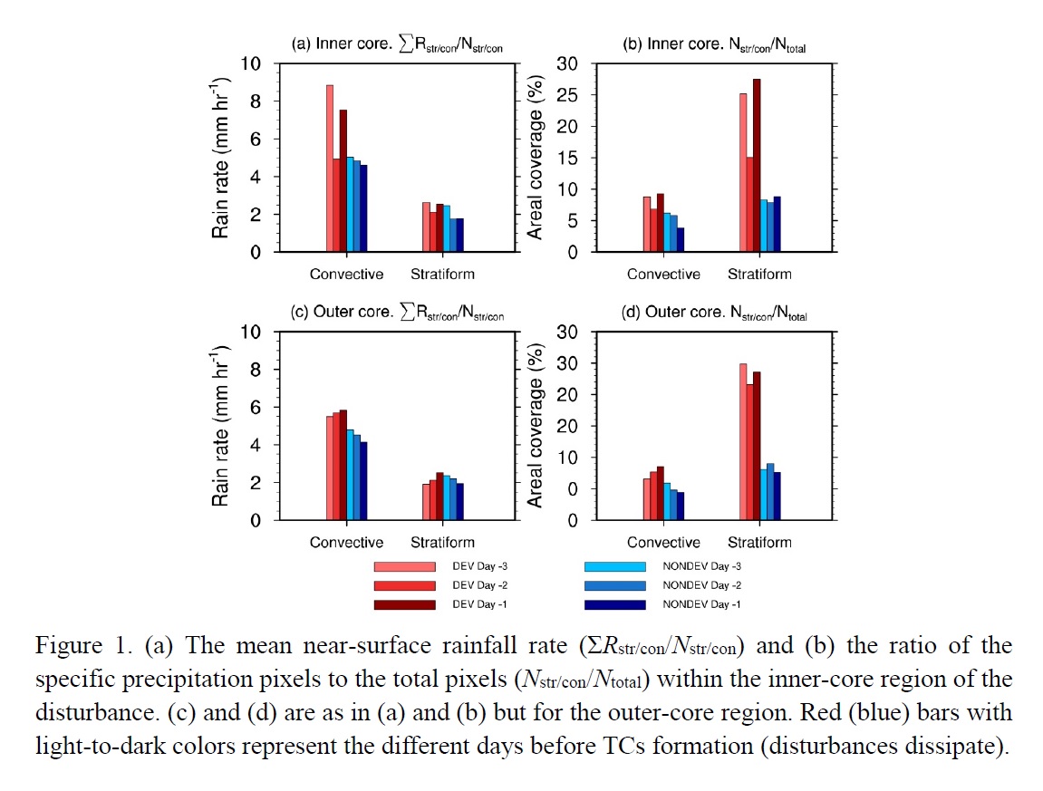
Highlights:
- The disturbances over WNP are categorized into developing and nondeveloping groups to investigate the differences between satellite-retrieved convective and stratiform precipitation properties in both the inner- and outer-core regions.
- The disturbances prone to develop into a TC over the WNP satisfy the following two essential preconditions in terms of precipitation characteristics.
- TC formations evolving from parent disturbances can be regarded as an outcome of the joint contribution from the two distinct types of precipitation cloud.
Notes and Correspondence
Ohno et al. (2020)
Ohno, T., A. T. Noda, and M. Satoh, 2020: Impacts of sub-grid ice cloud physics in a turbulence scheme on high clouds and their response to global warming. J. Meteor. Soc. Japan, 98, 1069-1081.
https://doi.org/10.2151/jmsj.2020-054
Graphical Abstract
Plain Language Summary: It has been recognized that the turbulent effects influence the cloud dynamics and the representation of moist process is critical for the performance of the sub-grid-scale (SGS) turbulence schemes. This note reports on the large impact of the representation of ice phase clouds in the turbulent closure scheme on the high clouds and their response to global warming, which underlines the critical nature of the treatment of SGS ice clouds which reflects a realistic ice condensation physics not only for a better representation of high clouds in the current climate but for an improved projection of changes of high clouds due to global warming.
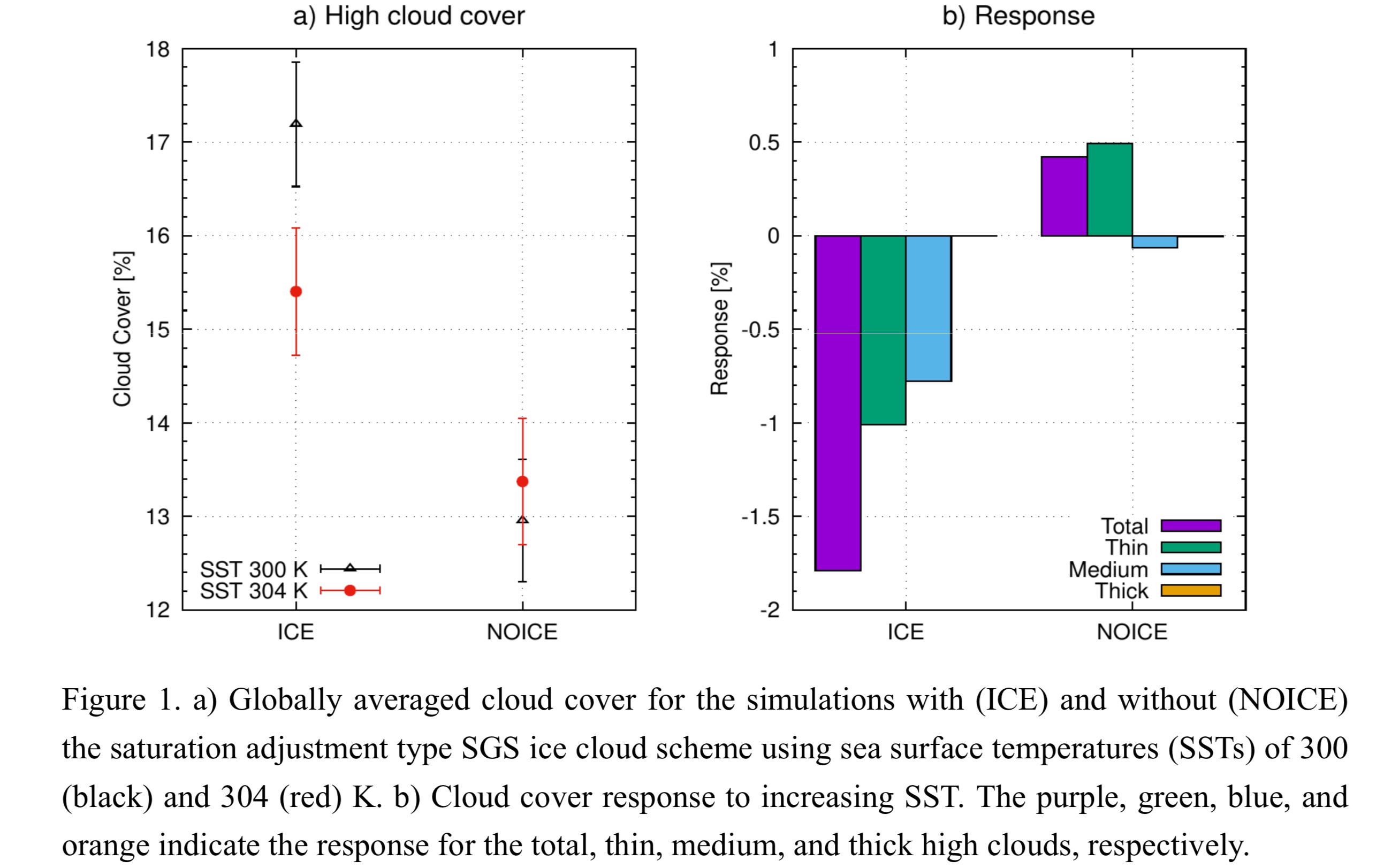
Highlights:
- The impacts of the saturation adjustment type approach to sub-grid-scale (SGS) ice clouds in a turbulence scheme on the high clouds and their response to global warming were investigated.
- The SGS ice cloud scheme modulated largely the high cloud covers and caused a significantly different response of high cloud amounts to global warming.
- Since the representation of high clouds is critical for the representation of climatological fields, the improvement of the treatment of SGS ice clouds physics in the turbulence should be desirable.
Notes and Correspondence
Krzyścin (2020)
Krzyścin, J., 2020: Is the Antarctic ozone hole recovering faster than changing the stratospheric halogen changes? J. Meteor. Soc. Japan, 98, 1083-1091.
https://doi.org/10.2151/jmsj.2020-055
Graphical Abstract
Plain Language Summary: Large ozone deficit over Antarctica has been observed regularly in austral spring since the early 1980s. The size and depth of the ozone hole vary considerably from year-to-year. The hole appears to have lost strength in the past 20 years because of declining levels of the man-made ozone-depleting chemicals in the stratosphere. This paper introduces indices for tracing the hole recovery: percentage of the healed amount of the ozone hole metric (total column ozone, hole area, and mass of ozone loss within the hole) by 2019, and the metric recovery year. In late winter and early spring, the metrics show stronger hole recovery than expected based on recent changes in ozone-depleting substances in the stratosphere.
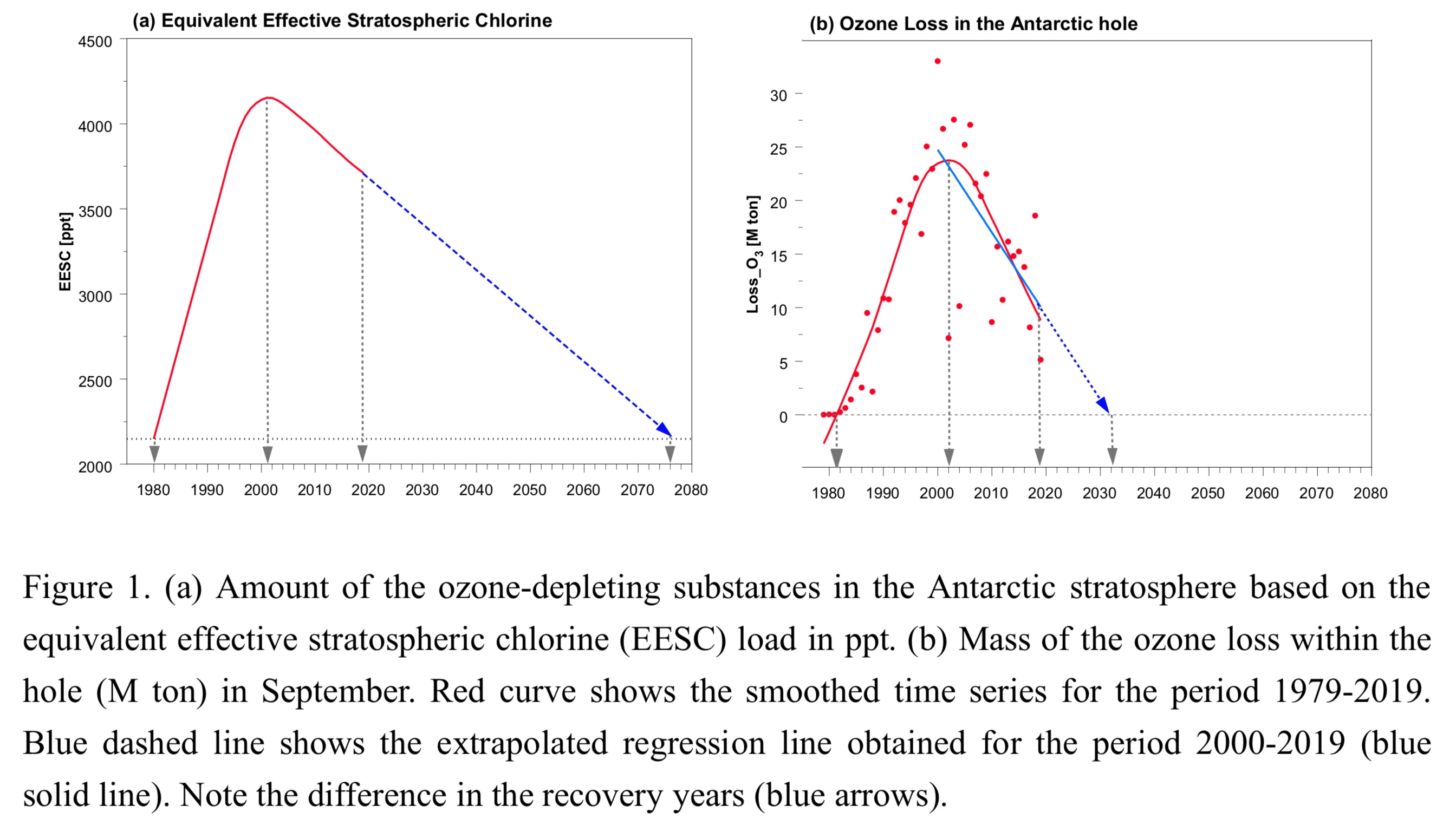
Highlights:
- Indicators to monitor the Antarctic ozone hole recovery are proposed: percentage of the healed amount of the hole metric (total column ozone, hole area, and mass of ozone loss within the hole) by 2019, and the metric recovery year.
- The statistically significant recovery is found from beginning of September up to mid-November based on mass of the ozone loss within the hole.
- In late austral winter and early spring, the recovery inferred from mass of the ozone loss within the hole is significantly stronger than expected based on changes in the stratospheric halogen loading alone.
JMSJ, 2020, Vol. 98, No. 6 (December)
Review Articles
Kawai and Shige (2020)
Kawai, H., and S. Shige, 2020: Marine low clouds and their parameterization in climate models. J. Meteor. Soc. Japan, 98, 1097-1127.
https://doi.org/10.2151/jmsj.2020-059
Graphical Abstract
Plain Language Summary: The first part of this review paper aims to provide readers with a broad range of meteorological backgrounds with basic information on marine low clouds and their importance in climate simulations. In the latter half of the paper, the concept of cloud parameterizations that determine cloud fraction and cloud water content in global climate models is introduced.
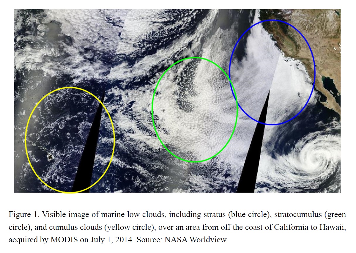
Highlights:
- Basic information on marine low clouds, including the global distribution and related physical processes, and the importance of such clouds in climate simulations are introduced.
- A concept of cloud parameterizations that determine cloud fraction and cloud water content in global climate models, which is sometimes called cloud “macrophysics”, is explained.
- Challenges related to cloud representation in global climate models that must be tackled in the next couple of decades are discussed.
Articles
Liao et al. (2020)
Liao, L., R. Meneghini, A. Tokay, and H. Kim, 2020: Assessment of Ku- and Ka-band Dual-frequency radar for snow retrieval. J. Meteor. Soc. Japan, 98, 1129-1146.
https://doi.org/10.2151/jmsj.2020-057
Graphical Abstract
Plain Language Summary: Dual-frequency radars have been increasingly used for detecting and retrieving frozen precipitation. However, retrieval of snow parameters has two principal errors, namely, the differences between the assumed particle size distribution (PSD) model from the actual PSD and inadequacies in characterizing the single-scattering properties of snowflakes. This study is aimed at evaluating uncertainties of snow precipitation estimation associated with the PSD models and scattering models and understanding their respective contributions to overall uncertainties for gaining insight into how to improve the retrieval methods for the GPM DPR operating at the Ku- and Ka-bands.
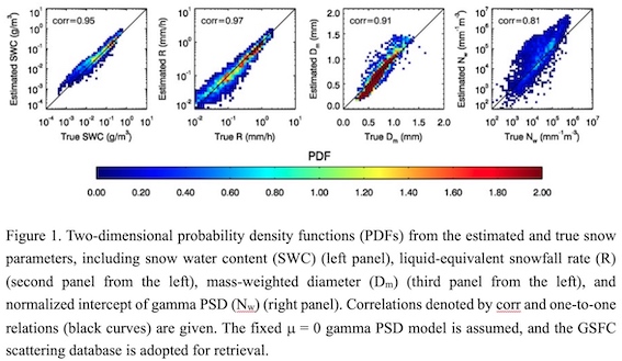
Highlights:
- This study, based on radar simulations from observed PSD data, shows that there exist relatively high correlations between the estimated snow parameters and their true values derived directly from the measured PSD.
- A gamma PSD model with a fixed shape factor equal to 0 (or exponential distribution) provides the best estimates of liquid-equivalent snowfall rate and mass-weighted diameter.
- Use of an inappropriate single scattering table alone could cause at least 30%-50% changes in snow retrieval.
Articles
Nayak and Takemi (2020)
Nayak, S., and T. Takemi, 2020: Clausius-Clapeyron scaling of extremely heavy precipitations: Case studies of the July 2017 and July 2018 heavy rainfall events over Japan. J. Meteor. Soc. Japan, 98, 1147-1162.
Special Edition on Extreme Rainfall Events in 2017 and 2018
https://doi.org/10.2151/jmsj.2020-058
Graphical Abstract
Plain Language Summary: The usefulness of Clausius-Clapeyron (CC) scaling in explaining extremely heavy precipitations is explored in the present-day climate and in pseudo-global-warming (PGW) conditions. This is analyzed by conducting regional-scale numerical simulations for two recent extreme rainfall events that occurred in Japan: the case in northern Kyushu during 5-6 July 2017 and the case in Shikoku Island during 5-8 July 2018.This study conducts the Ultra-high-resolution (5-km to 250-m grid spacing) numerical weather prediction (NWP) experiments and investigates the impacts of model resolutions on the Hiroshima heavy rain event in August 2014. The results show that the finer resolution model well reproduces the torrential rain event and the simulated convective cores (CCs) tend to converge when the resolution goes beyond 500 m.
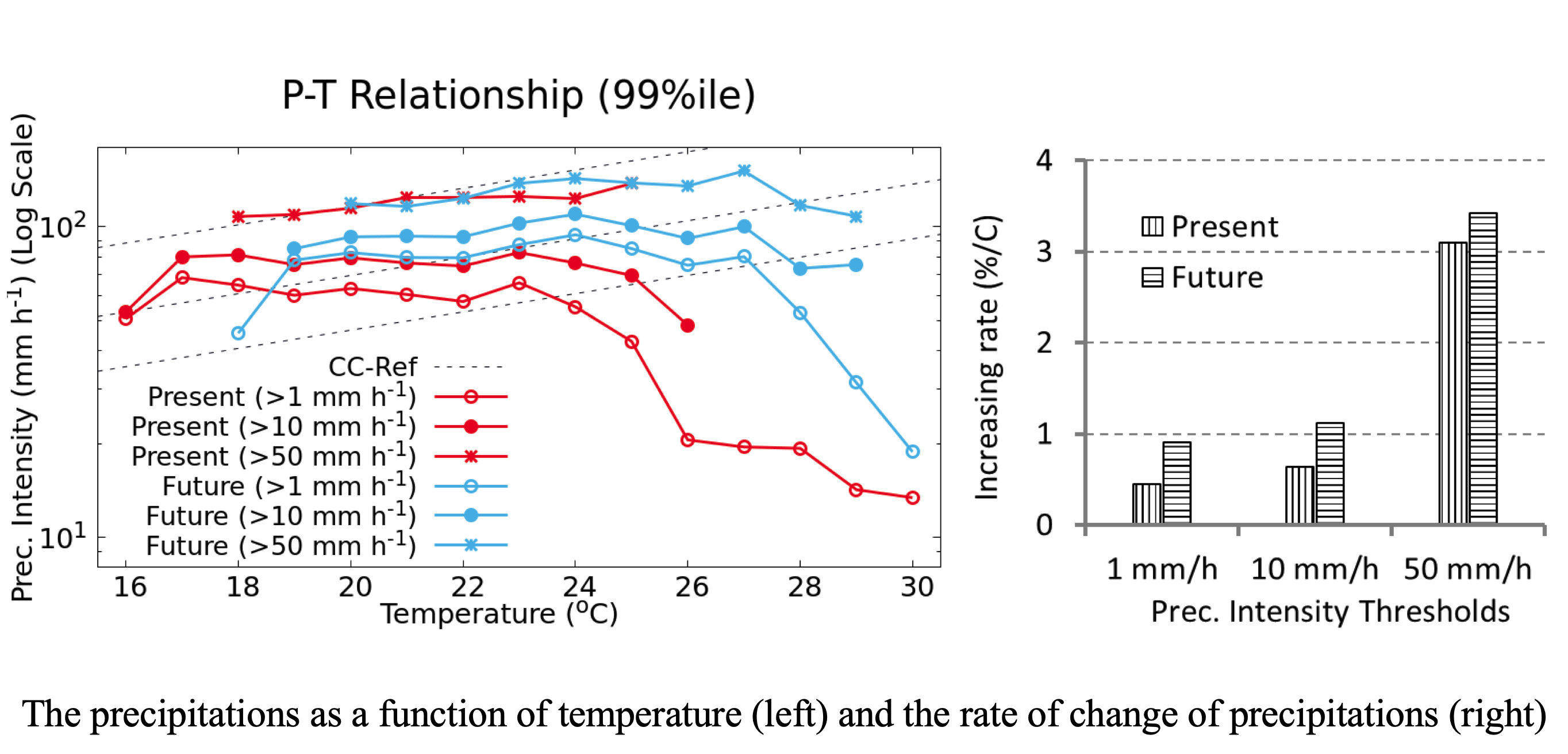
Highlights:
- The extremely heavy precipitations (>50 mm h-1) followed CC scaling for the temperatures up to 22°C in the present-day climate, while those under the PGW conditions follow CC-scaling up to 24°C.
- The increasing rate of the extremely heavy precipitations in the present-climate condition is noticed as ~3% °C-1 and that under the PGW conditions is anticipated as ~3.5% °C-1.
- The study suggests that the extremely heavy precipitations in future warming climate will be more intense and may cause local flooding and landslides and CC scaling of extreme precipitations exists up to certain temperature over western parts of Japan.
Articles
Oizumi et al. (2020)
Oizumi, T., K. Saito, L. Duc, and J. Ito, 2020: Ultra-high resolution numerical weather prediction with a large domain using the K computer. Part 2: The case of the Hiroshima heavy rainfall event on August 2014 and dependency of simulated convective cells on model resolutions. J. Meteor. Soc. Japan, 98, 1163-1182.
https://doi.org/10.2151/jmsj.2020-060
Graphical Abstract
Plain Language Summary: This study conducts the Ultra-high-resolution (5-km to 250-m grid spacing) numerical weather prediction (NWP) experiments and investigates the impacts of model resolutions on the Hiroshima heavy rain event in August 2014. The results show that the finer resolution model well reproduces the torrential rain event and the simulated convective cores (CCs) tend to converge when the resolution goes beyond 500 m.
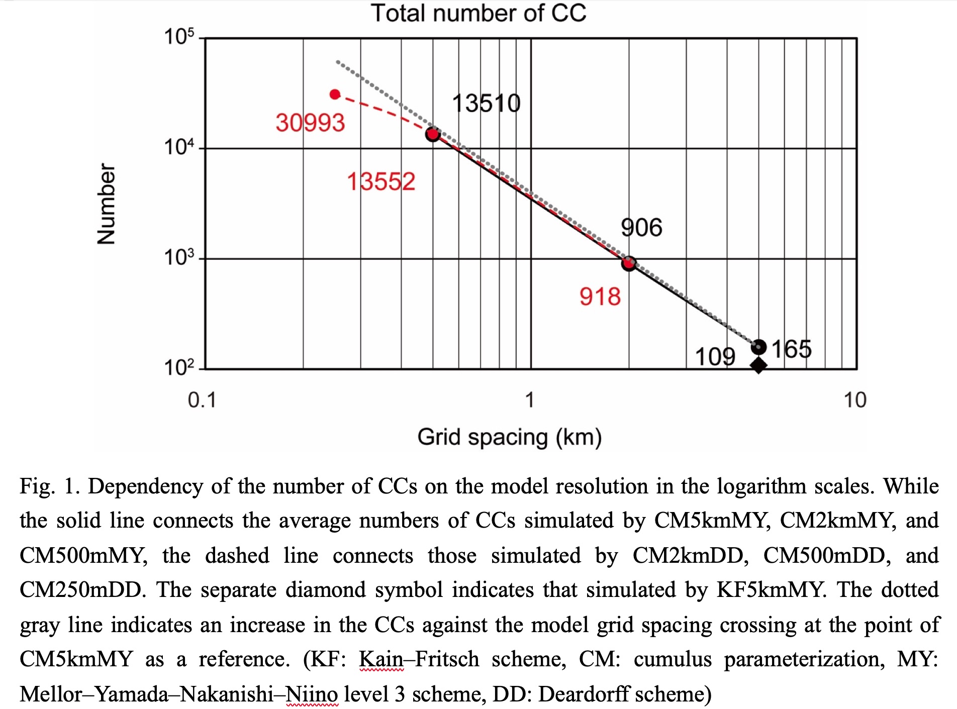
Highlights:
- The local rate of change of the number of CCs with respect to the model resolution was found to start decreasing at very high resolutions of around 500-m grid spacing.
- This implies that the number of CCs tends to converge when the resolution goes beyond 500 m.
Articles
Takemura and Mukougawa (2020)
Takemura, K., and H. Mukougawa, 2020: Maintenance mechanism of Rossby wave breaking and Pacific-Japan pattern in boreal summer. J. Meteor. Soc. Japan, 98, 1183-1206.
https://doi.org/10.2151/jmsj.2020-061
Graphical Abstract
Plain Language Summary: A maintenance mechanism for Rossby wave breaking (RWB) east of Japan and Pacific-Japan (PJ) pattern in boreal summer, which are triggered due to Rossby wave propagation along the Asian jet, is diagnosed by lag composite, correlation, and forward trajectory analyses, using a reanalysis dataset. A comparison between the composites of 7 persistent and 7 non-persistent cases, which are classified from the past 44 RWB cases, indicates that the persistent case shows the stronger and longer-lived Rossby wave propagation along the Asian jet. The subsequent stronger RWB in the persistent case causes the consequential formation of the more enhanced PJ pattern, through the stronger high potential vorticity intrusion toward the subtropical western North Pacific (WNP). The other main findings are summarized as follows.
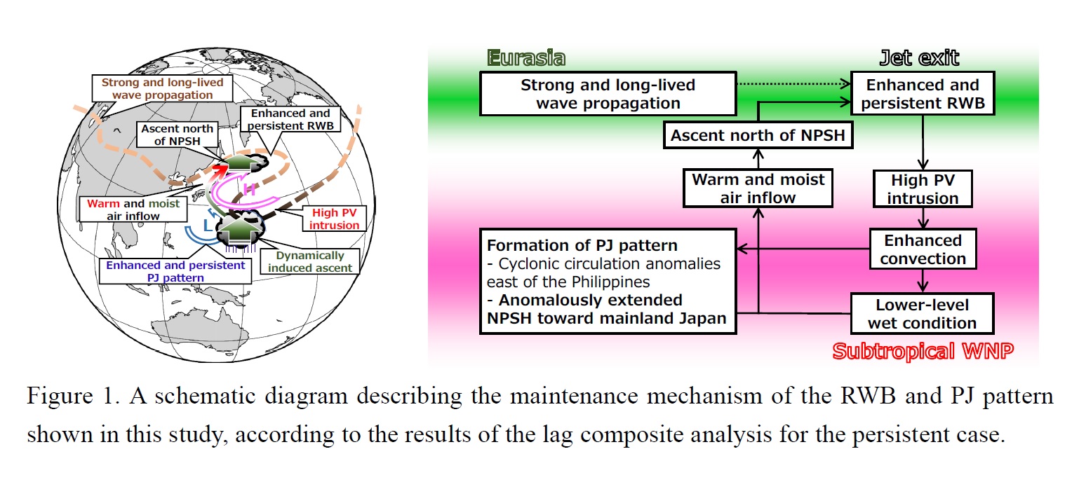
Highlights:
- Q-vector diagnosis and partial correlation analysis indicate that the mid-tropospheric anomalous warm air advection north of the anomalously extended North Pacific Subtropical High (NPSH) associated with the PJ pattern is closely associated with dynamically induced anomalous ascent from Japan to the east by an adiabatic process.
- Enhanced anomalous moisture flux convergence from Japan to the east, which is due to moisture inflow along the fringe of NPSH from the subtropical WNP, also causes the anomalous ascent over the region by a diabatic process.
- The anomalous ascents by the adiabatic and diabatic processes contribute to the enhanced and persistent RWB with nearly equivalent associations, through negative vorticity tendency due to vortex squashing in the upper troposphere, which further contributes to the enhanced and persistent PJ pattern in the persistent case.
Articles
Harada et al. (2020)
Harada, Y., H. Endo, and K. Takemura, 2020: Characteristics of large-scale atmospheric fields during heavy rainfall events in western Japan: Comparison with an extreme event in early July 2018. J. Meteor. Soc. Japan, 98, 1207-1229.
https://doi.org/10.2151/jmsj.2020-062
Graphical Abstract
Plain Language Summary: To explore large-scale atmospheric factors causing heavy rainfall events that occurred widely in western Japan, a composite analysis of atmospheric fields during the past heavy rainfall events in the region is performed. We also investigate atmospheric fields during an extreme heavy rainfall event that occurred in early July 2018 (HR18).
Highlights:
- The composite analysis indicates that a clear wave train due to quasi-stationary Rossby wave-packet propagation (RWPP) along the polar front jet over Siberia tends to occur just before TP10.
- Surface high-pressure anomalies to the southeast of Japan are dominated by variability with a 25–90-day period, whereas variability with an 8–25-day period dominates lower-pressure anomalies over the East China Sea (ECS) in relation to the development of the upper-tropospheric trough around the Korean Peninsula (KP).
- During HR18, a low-pressure system with an 8–25-day period to the south of Japan developed in association with wave breaking induced by the remarkable RWPP along the sub-tropical jet and propagated northwestward toward the ECS and then to Japan.
- HR18 is also characterized by a sharp upper-tropospheric trough over the KP that is dominated by high-frequency variability with a period less than 8 days.
Articles
Zhou et al. (2020)
Zhou, X., L. Wu, Q. Liu, and Y. Zheng, 2020: Influence of low-level, high-entropy air in the eye on tropical cyclone intensity: A trajectory analysis. J. Meteor. Soc. Japan, 98, 1231-1243.
https://doi.org/10.2151/jmsj.2020-063
Graphical Abstract
Plain Language Summary: Whether the high-entropy eye air can substantially increase tropical cyclone (TC) intensity through mixing with eyewall air and enhancing eyewall convection is still a scientific issue. This study quantitatively evaluates the relative importance of the entrainment of this air by trajectory analysis. The result suggests that the low-level, high-entropy air from the eye has little direct influence on TC intensity by providing relatively small mass and thermodynamic contributions.
Highlights:
- The entrainment occurs favorably on the quadrants of enhanced eyewall convection and is enhanced in the presence of small-scale disturbances in the inner edge of the eyewall.
- The eye air from the low-level, high-entropy reservoir accounts for 5.8% of the equivalent potential temperature change below 3 km and 4.5% of the total mass transport at 3 km in the TC eyewall.
Iwakiri and Watanabe (2020)
Iwakiri, T., and M. Watanabe, 2020: Multiyear La Niña impact on summer temperature over Japan. J. Meteor. Soc. Japan, 98, 1245-1260.
https://doi.org/10.2151/jmsj.2020-064
Graphical Abstract
Plain Language Summary: La Niña event often occurs in two consecutive years and is known as multiyear La Niña. Two distinct mechanisms bring different type hot summer in Japan during multiyear event. First year tend to be warm over the southwestern Japan in late summer, while second year experiences hot conditions over the northeastern Japan in midsummer. Both mechanisms are excited by suppressing convective activity over the central and eastern equatorial Pacific.
Highlights:
- Warm conditions are found in August-October (June-August) in the southwestern (northeastern) part of Japan during first (second) summer.
- Two different mechanisms bring hot summer in Japan; Matsuno-Gill response induces southwesterly warm advection and midlatitude Rossby response induces barotropic high-pressure.
- Distinct teleconnection between two years can be explained by seasonal march of mean states and delayed effect of preceding El Niño.
Tamura and Sato (2020)
Tamura, K., and T. Sato, 2020: Responses of polar mesocyclone genesis to topographic forcing along the eastern coast of Eurasian continent. J. Meteor. Soc. Japan, 98, 1261-1277.
https://doi.org/10.2151/jmsj.2020-065
Graphical Abstract
Plain Language Summary: Polar mesocyclones (PMCs) genesis over the offshore west of Hokkaido is affected by the mountains at the eastern end of the Eurasian continent. In the experiment without the mountains, strong westerly from the continent blow over the southern part of offshore west of Hokkaido. Consequently, PMCs tend to make landfall earlier and before reaching maturity. In contrast, the low-level wind over the Strait of Tartary prior to PMC genesis is unaffected by the removal of the mountains. Thus, topographic effects are not important for PMC genesis in this region.
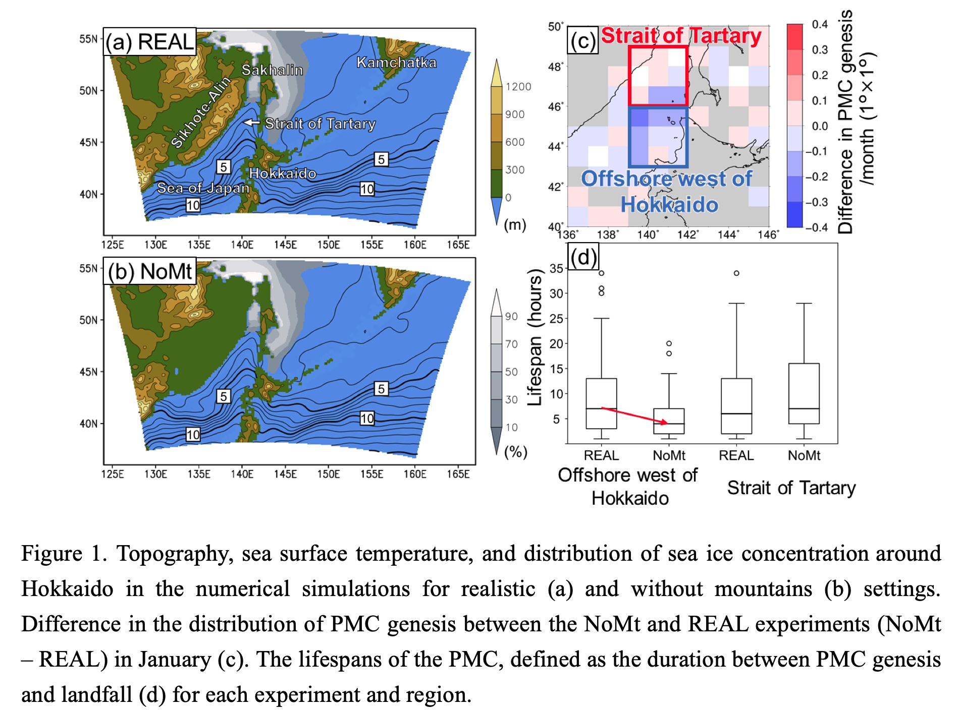
Highlights:
- Long-term numerical simulations extending over 36 winter seasons are performed to examine the topographic effects on various types of PMCs.
- The mountainous topography over the eastern end of the Eurasian continent has a role to weaken the low-level westerly over the offshore west of Hokkaido, which promotes the genesis of matured PMCs by extending the duration that they develop over the sea.
- This paper revealed that the responses of PMCs to topographic forcing has a regional variability.
Arnold et al. (2020)
Arnold, N. P., W. M. Putman, and S. R. Freitas, 2020: Impact of resolution and parameterized convection on the diurnal cycle of precipitation in a global nonhydrostatic model. J. Meteor. Soc. Japan, 98, 1279-1304.
https://doi.org/10.2151/jmsj.2020-066
Graphical Abstract
Plain Language Summary: We evaluate the diurnal cycle of precipitation and organized convection in a set of nonhydrostatic global model runs with horizontal grid spacing ranging from 50 km to 3.5 km, using the NASA GEOS model, with scale-aware Grell-Freitas parameterized convection. The 3.5 km experiments are repeated with Grell-Freitas turned off, and again with scale-awareness disabled, to illustrate the impact of parameterized convection.
Highlights:
- High resolution shows greatest benefit in regions dominated by non-local propagating convection, but produces peaks too early in the day in locally-forced regions.
- Experiments with strong parameterized convection show diurnal amplitudes similar to the observed climatology, whereas those relying on explicit convection develop unrealistic small-scale variability.
- Some parameterized deep convection is beneficial for the diurnal amplitude and phase even with a 3.5 km model grid, but only when throttled with the scale-aware approach.
Kawazoe et al. (2020)
Kawazoe, S., M. Fujita, S. Sugimoto, Y. Okada, and S. Watanabe, 2020: Projected changes of extremely cool summer days over northeastern Japan simulated by 20 km-mesh large ensemble experiment. J. Meteor. Soc. Japan, 98, 1305-1319.
https://doi.org/10.2151/jmsj.2020-067
Graphical Abstract
Plain Language Summary: Future changes to extreme cool days (ECDs) during the summer season (June – August) in northeast Japan is examined using the database for Policy Decision making for Future climate change (d4PDF) large ensemble experiments. We applied self-organizing maps (SOMs) to mean sea level pressure (MSLP) patterns, which were then classified into four clusters with high ECD occurrences. The response of the four clusters to a 2K and 4K warming scenarios was investigated, focusing on the role of low-level thermal advection.
Highlights:
- Four clusters producing ECDs were characterized by a presence of the Okhotsk Sea high, low-pressure system off eastern Japan, or a strong low-pressure center near the Bering Sea.
- Regardless of the circulation patterns, weaker cold air advection approaching northeast Japan is seen in the +2K climate and continues to weaken in +4K climate, due to positive changes in meridional temperature gradient near the area of strong cold air advection.
- While ECDs are projected to persist in future climates, they may not be as anomalously cool compared to what is experienced presently.
Yamaguchi and Maeda (2020)
Yamaguchi, M., and S. Maeda, 2020: Slowdown of Typhoon Translation Speeds in Mid-latitudes in September Influenced by the Pacific Decadal Oscillation and Global Warming. J. Meteor. Soc. Japan, 98, 1321-1334.
https://doi.org/10.2151/jmsj.2020-068
Graphical Abstract
Plain Language Summary: This study investigated whether the translation speed of tropical cyclones (TCs) has slowed in the western North Pacific basin during a post-geostationary satellite era from 1980-2019. Analyses of observational data and atmospheric reanalysis products revealed that the TC translation speed has significantly diminished over Japan, the East China Sea and their surrounding areas in September over the last 40 years. Historical model simulations with and without observational global warming trends reveal two main factors responsible for the translation speed slowdown: the Pacific Decadal Oscillation and global warming. Model simulations for a future warmer climate show that global warming further reduces the steering flows, leading to more slowly-moving TCs in autumn in the future.
Highlights:
- Both the natural climate decadal variabilities and global warming can make the TC translation speed slower, but the effects are not uniform in time and space (This is an important message to disaster preparedness communities).
- More caution is needed when the slowdown caused by the Pacific Decadal Oscillation is combined with the slowdown caused by global warming to increase the risk of extreme weather events.
- With the synergistic effects of increase in the rain rate associated with TCs and decrease in TC translation speeds, the accumulated precipitation at a given location will significantly increase in autumn in the future.
Huang et al. (2020)
Huang, Q., X. Ge, and M. Peng, 2020: Impacts of an upper-level easterly wave on the sudden track change of Typhoon Megi (2010). J. Meteor. Soc. Japan, 98, 1335-1352.
https://doi.org/10.2151/jmsj.2020-069
Graphical Abstract
Plain Language Summary: The Advanced Weather Research and Forecasting (WRF-ARW) model is used to investigate possible influences of a predominantly upper-level easterly wave (EW) on Typhoon Megi’s (2010) sharp northward turn on 20 October, 2010 after passing over the Philippines. In the presence of the upper-level easterly wave (EW), the simulation reasonably well produced the sudden track change of Megi.
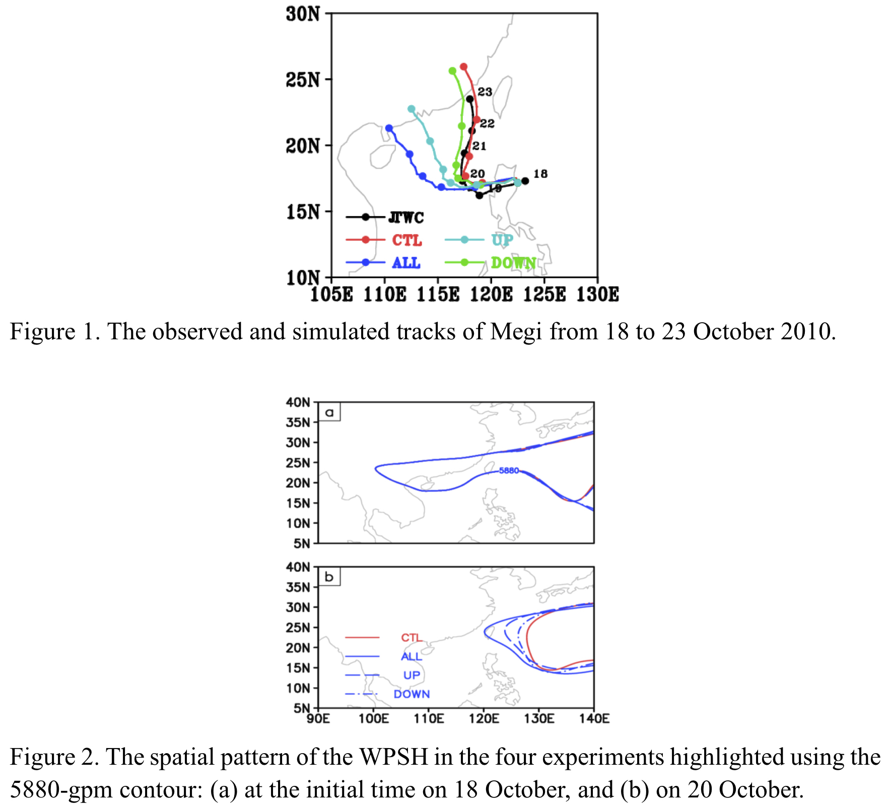
Highlights:
- An upper-level EW slows down Megi’s westward propagation to locate in the eastern semicircle of the nearby monsoon gyre, by which the enhanced southerly steering flow leads to a sharp northward turn.
- The cyclonic vorticity induced by the middle-level convergence erodes the western flank of the western North Pacific Subtropical High and thus changes the steering flow.
Zou et al. (2020)
Zou, S., J. Abuduwaili, J. Ding, W. Duan, P. De Maeyer, and T. Van de Voorde, 2020: Description and attribution analysis of the 2017 spring anomalous high temperature causing floods in Kazakhstan. J. Meteor. Soc. Japan, 98, 1353-1368.
Special Edition on Extreme Rainfall Events in 2017 and 2018
https://doi.org/10.2151/jmsj.2020-070
Graphical Abstract
Plain Language Summary: It is speculated that floods in many areas of the world have become more severe with global warming. This study describes and evaluated the attributable risk of the 2017 spring floods in Kazakhstan. The primary cause is that the north plains of Kazakhstan had a higher (March–April) mean temperature anomaly compared to the south plains, up to 3°C, relative to the 1901–2017 average temperature. And there was also a strong anthropogenic influence on the risk of the floods. Results provide essential information for a comprehensive understanding of the floods in Kazakhstan and will help government officials identify flooding situations and mitigate damage in future.
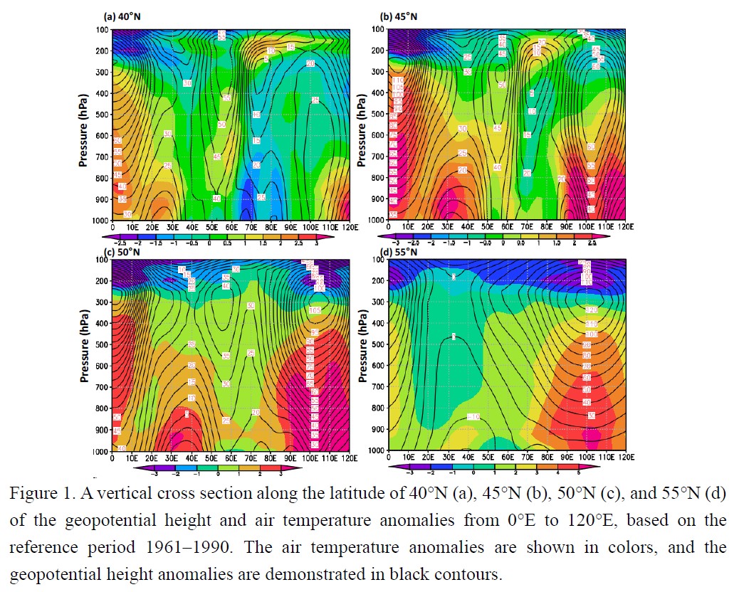
Highlights:
- The warmer abnormal temperature in March–April 2017 was the primary cause of flooding in Kazakhstan.
- A blocking high in the east of Kazakhstan directly caused a positive anomaly of the geopotential height and air temperature in the March–April 2017 period, eventually leading to a warmer abnormal spring temperature in Kazakhstan.
- The risk of the 2017 March–April floods in Kazakhstan could be attributed to anthropogenic forcing.
Tseng et al. (2020)
Tseng, W.-L., C.-C. Hong, M.-Y. Lee, H.-H. Hsu and C.-C. Chang, 2020: Compound effect of local and remote sea surface temperature on the unusual 2018 western North Pacific summer monsoon. J. Meteor. Soc. Japan, 98, 1369-1385.
Special Edition on Extreme Rainfall Events in 2017 and 2018
https://doi.org/10.2151/jmsj.2020-071
Graphical Abstract
Plain Language Summary: In July and August (JA) 2018, the monsoon trough in the western North Pacific (WNP) was unusually strong, the anticyclonic ridge was anomalously northward-shifted, and enhanced and northward-shifted tropical cyclone activity was observed. This study proposed that the local effect of both the tropical and extratropical WNP SST anomaly as the major driver and the remote effect of the North Atlantic SST anomaly as a minor contributor jointly induced the anomalous circulation and climate extremes in the WNP during JA 2018.
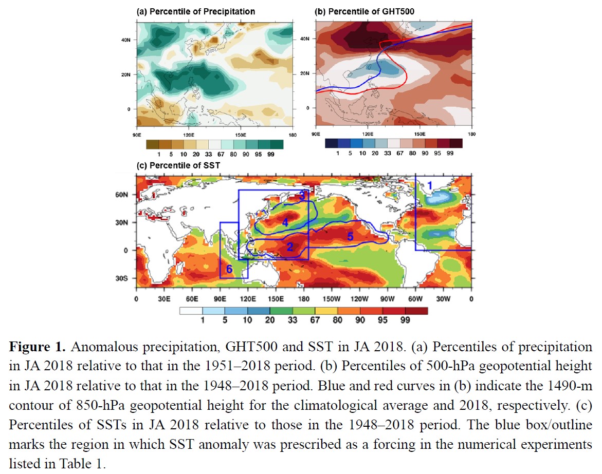
Highlights:
- The joint influences of the SST anomalies in both the tropical and extratropical WNP was the major factor that strengthened the WNP summer monsoon and the northward shift of the Pacific subtropical high.
- The North Atlantic (NA) SST anomaly also enhanced the monsoon trough in the presence of WNP SST anomaly.
- The individual SST anomaly in the NA, Indian Ocean, the extratropical WNP, and the subtropical eastern North Pacific could not force the enhanced monsoon trough.